
Make a donation
Gear up for your next adventure:
As an Amazon Associate, this site earns from qualifying purchases at no extra cost to you.
De Soto Parish topographic map
Click on the map to display elevation.
Make a donation
Gear up for your next adventure:
As an Amazon Associate, this site earns from qualifying purchases at no extra cost to you.
About this map
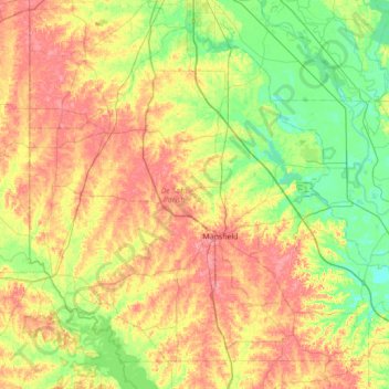
Name: De Soto Parish topographic map, elevation, terrain.
Location: De Soto Parish, Louisiana, United States (31.84429 -94.04308 32.34639 -93.35276)
Average elevation: 70 m
Minimum elevation: 30 m
Maximum elevation: 127 m
Make a donation
Gear up for your next adventure:
As an Amazon Associate, this site earns from qualifying purchases at no extra cost to you.
Other topographic maps
Click on a map to view its topography, its elevation and its terrain.
Lower Ninth Ward
United States > Louisiana > Orleans Parish > New Orleans
The most severely damaged section of the Ward was the lower elevation section, north of Claiborne Avenue. A Bring Back New Orleans Commission preliminary report suggested making this area in whole or part into park space because of the high risk of future flooding. Most Lower 9th Ward residents have strongly…
Average elevation: 1 m
Bell Fontaine
United States > Louisiana > East Baton Rouge Parish > Baton Rouge
Average elevation: 16 m
Make a donation
Gear up for your next adventure:
As an Amazon Associate, this site earns from qualifying purchases at no extra cost to you.
Goodwood Homesites
United States > Louisiana > East Baton Rouge Parish > Baton Rouge
Average elevation: 18 m
Mayfair Park North
United States > Louisiana > East Baton Rouge Parish > Baton Rouge
Average elevation: 12 m
Make a donation
Gear up for your next adventure:
As an Amazon Associate, this site earns from qualifying purchases at no extra cost to you.
Florida Plaza
United States > Louisiana > East Baton Rouge Parish > Baton Rouge
Average elevation: 19 m
Make a donation
Gear up for your next adventure:
As an Amazon Associate, this site earns from qualifying purchases at no extra cost to you.
Make a donation
Gear up for your next adventure:
As an Amazon Associate, this site earns from qualifying purchases at no extra cost to you.
Sherwood Forest
United States > Louisiana > East Baton Rouge Parish > Baton Rouge
Average elevation: 16 m
Make a donation
Gear up for your next adventure:
As an Amazon Associate, this site earns from qualifying purchases at no extra cost to you.
Steele Place
United States > Louisiana > East Baton Rouge Parish > Baton Rouge > Steele Place
Average elevation: 17 m
Tristian Village
United States > Louisiana > East Baton Rouge Parish > Baker > Tristian Village
Average elevation: 25 m
Highland Farms
United States > Louisiana > East Baton Rouge Parish > Baton Rouge > Highland Farms
Average elevation: 19 m
Make a donation
Gear up for your next adventure:
As an Amazon Associate, this site earns from qualifying purchases at no extra cost to you.
Laurens H Cohn Arboretum
United States > Louisiana > East Baton Rouge Parish > Yorkdale
Average elevation: 21 m
Make a donation
Gear up for your next adventure:
As an Amazon Associate, this site earns from qualifying purchases at no extra cost to you.
Glen Oaks
United States > Louisiana > East Baton Rouge Parish > Baton Rouge > Glen Oaks
Average elevation: 21 m
Prairieville
United States > Louisiana > Ascension Parish > Prairieville
Prairieville's latitude is 30.302N, and the longitude is -90.971W. The elevation is 23 feet (7.0 m).
Average elevation: 7 m
Parkview Oaks South
United States > Louisiana > East Baton Rouge Parish > Baton Rouge
Average elevation: 13 m
Make a donation
Gear up for your next adventure:
As an Amazon Associate, this site earns from qualifying purchases at no extra cost to you.