Geolocate

Milburn topographic map

Click on the map to display elevation.

About this map

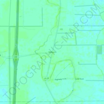
Name: Milburn topographic map, elevation, terrain.

Location: Milburn, Avoyelles Parish, Louisiana, United States (30.84769 -92.23179 30.88769 -92.19179)

Average elevation: 15 m

Minimum elevation: 11 m

Maximum elevation: 19 m

Other topographic maps

Click on a map to view its topography, its elevation and its terrain.

Mansura

United States > Louisiana > Avoyelles Parish > Mansura

Average elevation: 24 m

Gear up for your next adventure:

🧢Outdoor Visor - Breathable visor for sunny hikes
🪜Heavy Duty Carabiners - Multi-use clips for securing gear to your backpack
🥾Approach Boots - Comfortable boots for hiking and climbing approaches
👟Trail Running Shoes - Agile footwear for fast-paced topographic exploration
Camping Groundsheet - Protect your tent from moisture and dirt

As an Amazon Associate, this site earns from qualifying purchases at no extra cost to you.