
Xalisco topographic map
Click on the map to display elevation.
Xalisco
In the upper elevations there are still conifers and oaks, but over-forestry and long years of wood gathering for cooking have seriously depleted the natural cover. There are still deer, badgers, armadillos, and javelinas in more remote locations.
About this map
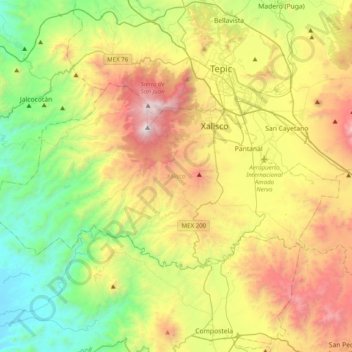
Name: Xalisco topographic map, elevation, terrain.
Location: Xalisco, Nayarit, Mexico (21.30168 -105.15337 21.49648 -104.75833)
Average elevation: 868 m
Minimum elevation: 19 m
Maximum elevation: 2,234 m
Other topographic maps
Click on a map to view its topography, its elevation and its terrain.
Tepic
Located in the central part of the state, it stands at an altitude of 915 metres (3,002 ft) above sea level, on the banks of the Río Mololoa and the Río Tepic, approximately 225 kilometres (140 mi) north-west of Guadalajara, Jalisco. Nearby are the volcanoes of San Juan, Las Navajas, and Sangangüey. Tepic…
Average elevation: 921 m
Tepic
Located in the central part of the state, it stands at an altitude of 915 metres (3,002 ft) above sea level, on the banks of the Río Mololoa and the Río Tepic, approximately 225 kilometres (140 mi) north-west of Guadalajara, Jalisco. Nearby are the extinct Sangangüey volcano and its crater lake. Tepic is…
Average elevation: 921 m
Tepic
Located in the central part of the state, it stands at an altitude of 915 metres (3,002 ft) above sea level, on the banks of the Río Mololoa and the Río Tepic, approximately 225 kilometres (140 mi) north-west of Guadalajara, Jalisco. Nearby are the volcanoes of San Juan, Las Navajas, and Sangangüey. Tepic…
Average elevation: 921 m