
Beltrami County topographic map
Interactive map
Click on the map to display elevation.
About this map
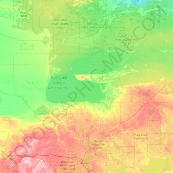
Name: Beltrami County topographic map, elevation, terrain.
Location: Beltrami County, Minnesota, United States (47.41027 -95.60268 48.54234 -94.41596)
Average elevation: 386 m
Minimum elevation: 338 m
Maximum elevation: 496 m
Other topographic maps
Click on a map to view its topography, its elevation and its terrain.
Boy Lake
United States > Minnesota > Itasca County
Boy Lake, Itasca County, Minnesota, United States
Average elevation: 422 m
Frontenac
United States > Minnesota > Goodhue County
Frontenac, Florence Township, Goodhue County, Minnesota, 55026, United States
Average elevation: 243 m
Border
United States > Minnesota > Koochiching County
Border, Koochiching County, Minnesota, United States
Average elevation: 333 m
Lakeville
United States > Minnesota > Dakota County
Lakeville, Dakota County, Minnesota, 55044, United States
Average elevation: 305 m
Edina
United States > Minnesota > Hennepin County
Edina, Hennepin County, Minnesota, United States
Average elevation: 271 m
Eagle Mountain
United States > Minnesota > Cook County
Eagle Mountain, West Cook, Cook County, Minnesota, United States
Average elevation: 596 m
Cyrus
United States > Minnesota > Pope County
Cyrus, Pope County, Minnesota, United States
Average elevation: 348 m
Plymouth
United States > Minnesota > Hennepin County
Plymouth, Hennepin County, Minnesota, United States
Average elevation: 294 m
Coffee Creek
United States > Minnesota > Lake County
Coffee Creek, Lake No. 1, Lake County, Minnesota, United States
Average elevation: 521 m
Ernest Lake
United States > Minnesota > Cook County
Ernest Lake, West Cook, Cook County, Minnesota, United States
Average elevation: 505 m
Apple Valley
United States > Minnesota > Dakota County
Apple Valley, Dakota County, Minnesota, 55124, United States
Average elevation: 301 m
Sandstone
United States > Minnesota > Pine County
Sandstone, Pine County, Minnesota, United States
Average elevation: 332 m
St. James
United States > Minnesota > Watonwan County
St. James, Watonwan County, Minnesota, 56081, United States
Average elevation: 328 m
Carey Creek
United States > Minnesota > Olmsted County
Carey Creek, Olmsted County, Minnesota, 55976, United States
Average elevation: 375 m
Alice Lake
United States > Minnesota > Lake County
Alice Lake, Fall Lake Township, Lake County, Minnesota, United States
Average elevation: 474 m
Elk River
United States > Minnesota > Sherburne County
Elk River, Sherburne County, Minnesota, 55330, United States
Average elevation: 283 m
Sea Gull Lake
United States > Minnesota > Cook County
Sea Gull Lake, West Cook, Cook County, Minnesota, United States
Average elevation: 460 m
Courtland
United States > Minnesota > Nicollet County
Courtland, Nicollet County, Minnesota, 56021, United States
Average elevation: 281 m
Edna Lake
United States > Minnesota > Aitkin County
Edna Lake, Aitkin County, Minnesota, United States
Average elevation: 411 m
Barnes Lake
United States > Minnesota > Carver County > Norwood Young America
Barnes Lake, Norwood Young America, Young America Township, Carver County, Minnesota, United States
Average elevation: 300 m
Lake Itasca
United States > Minnesota > Clearwater County
Lake Itasca, Clearwater County, Minnesota, United States
Average elevation: 463 m
Link Lake
United States > Minnesota > Lake County
Link Lake, Lake County, Minnesota, United States
Average elevation: 452 m
Howard Lake
United States > Minnesota > Wright County
Howard Lake, Wright County, Minnesota, 55349, United States
Average elevation: 312 m
Babbitt
United States > Minnesota > Saint Louis County
Babbitt, Saint Louis County, Minnesota, United States
Average elevation: 484 m
McGrath
United States > Minnesota > Aitkin County
McGrath, Aitkin County, Minnesota, United States
Average elevation: 379 m
Bloomington
United States > Minnesota > Hennepin County
Bloomington, Hennepin County, Minnesota, United States
Average elevation: 255 m
Ash Lake
United States > Minnesota > Saint Louis County
Ash Lake, Saint Louis County, Minnesota, United States
Average elevation: 413 m
Lakefield
United States > Minnesota > Jackson County
Lakefield, Jackson County, Minnesota, United States
Average elevation: 450 m
East Gull Lake
United States > Minnesota > Cass County
East Gull Lake, Cass County, Minnesota, United States
Average elevation: 370 m
Finlayson
United States > Minnesota > Pine County
Finlayson, Pine County, Minnesota, United States
Average elevation: 339 m
North Shore Mining/Lake Superior Overlook
United States > Minnesota > Lake County > Silver Bay
North Shore Mining/Lake Superior Overlook, City Shop Road, Silver Bay, Lake County, Minnesota, 55614, United States
Average elevation: 252 m
Lake Elmo
United States > Minnesota > Washington County
Lake Elmo, Washington County, Minnesota, 55042, United States
Average elevation: 287 m
Beauty Lake
United States > Minnesota > Kanabec County
Beauty Lake, Kanabec County, Minnesota, United States
Average elevation: 347 m
Grand Rapids
United States > Minnesota > Itasca County
Grand Rapids, Itasca County, Minnesota, 55744, United States
Average elevation: 398 m
Fosston
United States > Minnesota > Polk County
Fosston, Polk County, Minnesota, 56542, United States
Average elevation: 393 m
Lanesboro
United States > Minnesota > Fillmore County
Lanesboro, Fillmore County, Minnesota, 55949, United States
Average elevation: 299 m
Byron
United States > Minnesota > Olmsted County
Byron, Olmsted County, Minnesota, 55920, United States
Average elevation: 365 m
Wren Lake
United States > Minnesota > Cass County
Wren Lake, Cass County, Minnesota, United States
Average elevation: 418 m
Shorewood
United States > Minnesota > Hennepin County
Shorewood, Hennepin County, Minnesota, United States
Average elevation: 289 m
Faribault County
Faribault County, Minnesota, United States
Average elevation: 340 m
Gooseberry Lake
United States > Minnesota > Cass County
Gooseberry Lake, Cass County, Minnesota, United States
Average elevation: 418 m
Rainy River
United States > Minnesota > Koochiching County
Rainy River, Koochiching County, Minnesota, 56629, United States
Average elevation: 341 m
Marshall Lake
United States > Minnesota > Cook County
Marshall Lake, West Cook, Cook County, Minnesota, United States
Average elevation: 556 m
Cream Lake
United States > Minnesota > Cook County
Cream Lake, West Cook, Cook County, Minnesota, United States
Average elevation: 574 m
Duck Lake
United States > Minnesota > Crow Wing County > Crosslake
Duck Lake, Crosslake, Crow Wing County, Minnesota, United States
Average elevation: 377 m
George Lake
United States > Minnesota > Cook County
George Lake, West Cook, Cook County, Minnesota, United States
Average elevation: 551 m
Little Swan
United States > Minnesota > Saint Louis County > Hibbing
Little Swan, Hibbing, Saint Louis County, Minnesota, United States
Average elevation: 395 m
Zumbrota
United States > Minnesota > Goodhue County
Zumbrota, Goodhue County, Minnesota, 55992, United States
Average elevation: 312 m