Thuringia topographic map
Click on the map to display elevation.
About this map
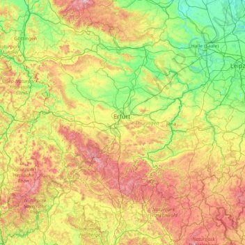
Name: Thuringia topographic map, elevation, terrain.
Location: Thuringia, Germany (50.20435 9.87696 51.64928 12.65392)
Average elevation: 341 m
Minimum elevation: 56 m
Maximum elevation: 1,135 m
Other topographic maps
Click on a map to view its topography, its elevation and its terrain.
Berlin
Berlin straddles the banks of the River Spree, which flows into the River Havel (a tributary of the River Elbe) in the western borough of Spandau. Among the city's main topographical features are the many lakes in the western and southeastern boroughs formed by the Spree, Havel, and Dahme rivers (the largest…
Average elevation: 47 m
Hamburg
The neighborhoods of Neuenfelde, Cranz, Francop and Finkenwerder are part of the Altes Land (old land) region, the largest contiguous fruit-producing region in Central Europe. Neugraben-Fischbek has Hamburg's highest elevation, the Hasselbrack at 116.2 metres (381 ft) AMSL. Hamburg borders the states of…
Average elevation: 23 m
Stuttgart
Germany > Baden-Württemberg > Stuttgart
Stuttgart covers an area of 207.35 km2 (80 sq mi) and sits at elevation ranging from 207 m (679 ft) above sea level by the Neckar river to 549 m (1,801 ft) on Bernhartshöhe hill – something rather unique in large German cities. The most prominent elevated locales in Stuttgart are the Birkenkopf (511 m…
Average elevation: 353 m
Hamburg
The neighborhoods of Neuenfelde, Cranz, Francop and Finkenwerder are part of the Altes Land (old land) region, the largest contiguous fruit-producing region in Central Europe. Neugraben-Fischbek has Hamburg's highest elevation, the Hasselbrack at 116.2 metres (381 ft) AMSL. Hamburg borders the states of…
Average elevation: 56 m


Wartburg
Germany > Thuringia > Wartburgkreis > Eisenach
The Wartburg (German pronunciation: [ˈvaʁtbʊʁk]) is a castle originally built in the Middle Ages. At an elevation of 410 metres (1,350 ft) in the state of Thuringia, Germany, it is situated on a southwest-facing precipice and overlooks the town of Eisenach to the north. It was the home of St. Elisabeth of…
Average elevation: 284 m


Dessau
Germany > Saxony-Anhalt > Dessau-Roßlau
Dessau is situated on a floodplain where the Mulde flows into the Elbe. This causes yearly floods. The worst flood took place in the year 2002, when the Waldersee district was nearly completely flooded. The south of Dessau touches a well-wooded area called Mosigkauer Heide. The highest elevation is a 110 m…
Average elevation: 62 m

Niedersfeld
Germany > North Rhine-Westphalia > Hochsauerlandkreis > Winterberg
Average elevation: 656 m

Dürselen
Germany > North Rhine-Westphalia > Rhein-Kreis Neuss > Jüchen > Kelzenberg
Average elevation: 72 m


Moselhöhe Ediger-Eller
Germany > Rhineland-Palatinate > Landkreis Cochem-Zell > Ediger-Eller
Average elevation: 285 m


Zugspitze
Germany > Bavaria > Landkreis Garmisch-Partenkirchen > Grainau
The mountain rises eleven kilometres southwest of Garmisch-Partenkirchen and just under six kilometres east of Ehrwald. The border between Germany and Austria runs over the west summit; thus the Zugspitze massif belongs to the German state of Bavaria and the Austrian state of Tyrol. The municipalities…
Average elevation: 2,300 m



Neuschwanstein Castle
Germany > Bavaria > Landkreis Ostallgäu > Hohenschwangau
The municipality of Schwangau lies at an elevation of 800 m (2,620 ft) at the southwest border of the German state of Bavaria. Its surroundings are characterised by the transition between the Alpine foothills in the south (toward the nearby Austrian border) and a hilly landscape in the north that appears flat…
Average elevation: 982 m

Danger of ground subsidence!
Germany > Brandenburg > Dahme-Spreewald > Luckau > Fürstlich Drehna
Average elevation: 78 m



Filde
Germany > North Rhine-Westphalia > Oberbergischer Kreis > Radevormwald > Wönkhausen
Average elevation: 341 m





Herrenschwand
Germany > Baden-Württemberg > Landkreis Lörrach > Todtnau > Präg
Average elevation: 981 m

Linderhof Palace
Germany > Bavaria > Landkreis Garmisch-Partenkirchen > Ettaler Forst
Average elevation: 1,109 m

Bredenfelde
Germany > Mecklenburg-Vorpommern > Mecklenburgische Seenplatte > Woldegk
Average elevation: 109 m

Bochen
Germany > North Rhine-Westphalia > Oberbergischer Kreis > Wipperfürth > Neye
Average elevation: 299 m



Bochum
Germany > North Rhine-Westphalia > Bochum
The city lies on the low rolling hills of Bochum land ridge (Bochumer Landrücken), part of the Ruhrhöhen (highest elevations) between the Ruhr and Emscher rivers at the border of the southern and northern Ruhr coal region. The highest point of the city is at Kemnader Straße (Kemnader Street) in Stiepel at…
Average elevation: 107 m


Paradies
Germany > Bavaria > Landkreis Lindau > Lindau (Bodensee) > Oberreitnau
Average elevation: 464 m




Wuppertal
Germany > North Rhine-Westphalia > Wuppertal
Uniquely for Germany, it is a "linear city", owing to the steep hillsides along the river Wupper. Its highest hill is the Lichtscheid, which is 351 metres above sea level. The dominant urban centres Elberfeld (historic commercial centre) and Barmen (more industrial) have formed a continuous urbanized area…
Average elevation: 209 m

Buchar
Germany > Mecklenburg-Vorpommern > Mecklenburgische Seenplatte > Altentreptow
Average elevation: 41 m


Blausee
Germany > Baden-Württemberg > Landkreis Ravensburg > Wangen im Allgäu > Neuravensburg > Maierhalden
Average elevation: 535 m


Ludwigsthal
Germany > Bavaria > Landkreis Regen > Lindberg
The chapelry of Ludwigsthal was established in 1894; this was followed in 1912 by its elevation to a parish.
Average elevation: 662 m



Becken
Germany > Lower Saxony > Landkreis Rotenburg (Wümme) > Steddorf > Boitzenbostel
Average elevation: 30 m

Nauheim
Germany > Rhineland-Palatinate > Landkreis Mainz-Bingen > Bacharach > Neurath
Average elevation: 251 m



Sirnitz
Germany > Baden-Württemberg > Landkreis Breisgau-Hochschwarzwald > Müllheim im Markgräflerland
Average elevation: 949 m