
Heidelberg topographic map
Click on the map to display elevation.
About this map
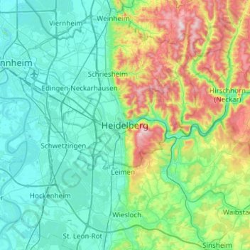
Name: Heidelberg topographic map, elevation, terrain.
Average elevation: 200 m
Minimum elevation: 87 m
Maximum elevation: 602 m
Other topographic maps
Click on a map to view its topography, its elevation and its terrain.
Heidelberg Castle
Germany > Baden-Württemberg > Heidelberg > Königstuhl
All of these works are for the most part superficial and do not contain much information. In 1615, Merian's Topographia Palatinatus Rheni described Prince Elector Ludwig V as he "started building a new castle one hundred and more years ago". Most of the descriptions of the castle up until the 18th century are…
Average elevation: 280 m