Geolocate

Ellen topographic map

Click on the map to display elevation.

About this map
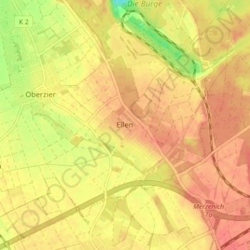
Name: Ellen topographic map, elevation, terrain.

Location: Ellen, Niederzier, Kreis Düren, North Rhine-Westphalia, 52382, Germany (50.84093 6.47527 50.88093 6.51527)

Average elevation: 119 m

Minimum elevation: 82 m

Maximum elevation: 136 m

Other topographic maps

Click on a map to view its topography, its elevation and its terrain.

Jülich

Germany > North Rhine-Westphalia > Kreis Düren

Average elevation: 98 m

Nideggen

Germany > North Rhine-Westphalia > Kreis Düren

Average elevation: 300 m

Linnich

Germany > North Rhine-Westphalia > Kreis Düren

Average elevation: 84 m

Duren

Germany > North Rhine-Westphalia > Kreis Düren

Average elevation: 145 m

Duren

Germany > North Rhine-Westphalia > Kreis Düren

Average elevation: 145 m

Duren

Germany > North Rhine-Westphalia > Kreis Düren

Average elevation: 145 m

Duren

Germany > North Rhine-Westphalia > Kreis Düren

Average elevation: 145 m

Koslar

Germany > North Rhine-Westphalia > Kreis Düren > Jülich

Average elevation: 90 m

Gear up for your next adventure:

🎒Backpack Rain Cover - External shield to keep your entire pack dry
💡Portable Camping Lamp - Rechargeable lamp for campsite lighting
🧥Softshell Hiking Jacket - The perfect balance of wind protection and breathability
🥾Mountain Hiking Shoes - Shoes with superior grip for mountainous terrain
🧴Insect Repellent - Protect yourself from bugs during outdoor adventures

As an Amazon Associate, this site earns from qualifying purchases at no extra cost to you.