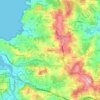
La Palma topographic map
Click on the map to display elevation.
La Palma
In a programme transmitted by the British Broadcasting Corporation BBC Horizon broadcast on 12 October 2000, two geologists (Day and McGuire) cited La Grieta as proof that half of the Cumbre Vieja had moved towards the Atlantic Ocean (Day et al. 1999, and Ward and Day, 2001). They postulate that this process was driven by the pressure caused by the rising magma heating water trapped within the structure of the island. They hypothesised that during a future eruption, the western flank of the Cumbre Vieja, with a mass of approximately 1.5 x10¹⁵ kg, could slide into the ocean. This could then potentially generate a giant wave, known as a "megatsunami" around 650–900 m (2,130–2,950 ft) high in the region of the islands. The wave would radiate out across the Atlantic and inundate much of the eastern seaboard of North America about 7 hours later, many of the islands in the Caribbean and northern coasts of South America between six and eight hours later. They estimate that the tsunami will have waves possibly 50 m (164 ft) or higher causing massive devastation along the coastlines. Modelling suggests that the tsunami could inundate up to 25 km (16 mi) inland – depending upon topography. The basis for Ward and Day (2001) modelling the collapse of a much larger portion of the western flank than what the currently visible surface crack indicates as being potentially unstable, was based on geological mapping by Day et al. (1999). In this paper they argue that a large part of the western flank has been constructed in the scar of a previous collapse and therefore sits upon unstable debris.
About this map
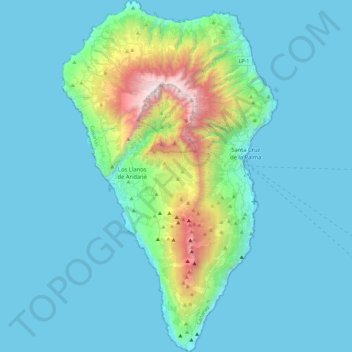
Name: La Palma topographic map, elevation, terrain.
Location: La Palma, Santa Cruz de Tenerife, Canary Islands, Spain (28.45269 -18.00725 28.85757 -17.72422)
Average elevation: 296 m
Minimum elevation: 0 m
Maximum elevation: 2,410 m
Other topographic maps
Click on a map to view its topography, its elevation and its terrain.
Zaragoza
On 1 January 2019 the population of the municipality of Zaragoza was 706,904, (the fifth most populated in Spain) on a land area of 973.78 square kilometres (375.98 square miles). The population of the metropolitan area was estimated in 2006 at 783,763 inhabitants. The municipality is home to more than 50…
Average elevation: 310 m
Granada
Spain > Andalusia > Granada > Granada
Granada (/ɡrəˈnɑːdə/ grə-NAH-də, Spanish: , locally ) is the capital city of the province of Granada, in the autonomous community of Andalusia, Spain. Granada is located at the foot of the Sierra Nevada mountains, at the confluence of four rivers, the Darro, the Genil, the Monachil and the Beiro.…
Average elevation: 1,043 m
Sierra Nevada
Spain > Andalusia > Comarca de Guadix
Parts of the range have been included in the Sierra Nevada National Park. The range has also been declared a biosphere reserve. The Sierra Nevada Observatory, the Calar Alto Observatory, and the IRAM 30m telescope are located on the northern slopes at an elevation of 2,800 metres (9,200 ft).
Average elevation: 1,310 m
Donostia / San Sebastián
Spain > Autonomous Community of the Basque Country > Donostialdea > Donostia / San Sebastián
Average elevation: 134 m
sa Calobra
Spain > Balearic Islands > Serra de Tramuntana > Escorca
The port village is a popular destination for coach trips and road cyclists. It is accessed by a single winding road, designed by Italian-Spanish engineer Antonio Parietti and opened in 1933, which features many hairpin bends and a 270° spiral bridge called the tie knot. The climb is officially called the…
Average elevation: 256 m
Hondarribia
Spain > Autonomous Community of the Basque Country > Bidasoa Beherea / Bajo Bidasoa > Hondarribia
Average elevation: 34 m
Sierra Nevada
Spain > Andalusia > Comarca de la Alpujarra Granadina > Lanjarón
Average elevation: 2,223 m

Unza
Spain > Autonomous Community of the Basque Country > Añanako kuadrilla/Cuadrilla de Añana > Zuhatzu Kuartango
Average elevation: 793 m



Port del Cantó
Spain > Catalonia > Alt Urgell > Montferrer i Castellbò
The Port del Cantó, or Coll del Cantó or Coll de la Pedra del Cantó, is a mountain pass at an altitude of 1,730 metres (5,680 ft) located at the border of the municipalities of Soriguera, in the comarca of Pallars Sobirà, and Montferrer i Castellbò in the comarca of Alt Urgell in Catalonia, Spain.
Average elevation: 1,758 m



Madrigal de la Vera
Spain > Extremadura > La Vera > Madrigal de la Vera > Madrigal de la Vera
Average elevation: 400 m


Foz de Arbaiun / Arbaiungo arroila
Spain > Zangozerria / Comarca de Sangüesa > Romanzado/Erromantzatua
Average elevation: 675 m



La Cuesta
Spain > San Cristóbal de La Laguna
La Cuesta has an area of 37.06 km² and an elevation of 38 metres.
Average elevation: 339 m


Santa Margarita
Spain > Andalusia > Campo de Gibraltar > La Línea de la Concepción
Average elevation: 63 m

Desert de les Palmes
Spain > Valencian Community > Castelló / Castellón > Benicàssim / Benicasim
Average elevation: 370 m
Río de la Toba
Spain > Andalusia > Comarca de la Costa Granadina > Los Guájares
Average elevation: 316 m


San Feliz de las Lavanderas
Spain > Castile and León > Quintana del Castillo
Average elevation: 1,166 m