Geolocate

Banyoles topographic map

Click on the map to display elevation.

About this map

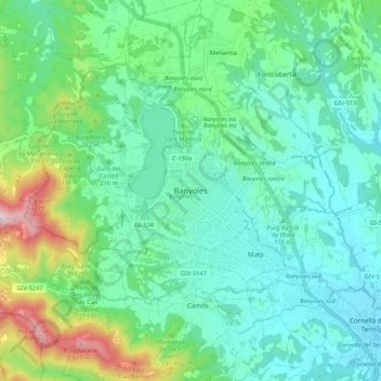
Name: Banyoles topographic map, elevation, terrain.

Location: Banyoles, Pla de l'Estany, Girona, Catalonia, 17820, Spain (42.07805 2.72536 42.15805 2.80536)

Average elevation: 217 m

Minimum elevation: 92 m

Maximum elevation: 622 m

Gear up for your next adventure:

🥾Mountain Hiking Boots - High-traction boots for rocky terrain
🥾Lightweight Hiking Shoes - Comfortable shoes for day hikes
🧴Waterproofing Spray - Restore the DWR coating on jackets and tents
🧢Outdoor Cap - Protective cap for sun and rain during hikes
🏃Hydration Running Vest - Carry water and maps close to your body for speed

As an Amazon Associate, this site earns from qualifying purchases at no extra cost to you.