Geolocate

Mogote topographic map

Click on the map to display elevation.

About this map

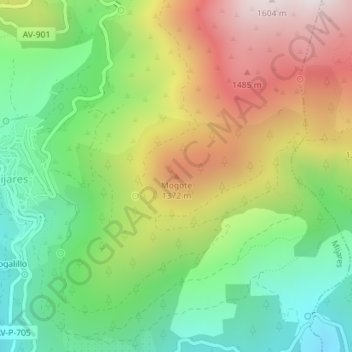
Name: Mogote topographic map, elevation, terrain.

Location: Mogote, Mijares, Ávila, Castile and León, 05461, Spain (40.29589 -4.82013 40.29599 -4.82003)

Average elevation: 1,079 m

Minimum elevation: 690 m

Maximum elevation: 1,616 m

Gear up for your next adventure:

🧰Survival Kit - Essential gear for emergencies in the wilderness
💧Filtered Water Bottle - Safe drinking water on the go
🔦LED Headtorch - Bright and durable light for night activities
🧭GPS Tracker - Track your location in remote areas safely
🥾Mountaineering Boots - Supportive boots for climbing and high-altitude hiking

As an Amazon Associate, this site earns from qualifying purchases at no extra cost to you.