
Préfecture d'Ehime topographic map
Interactive map
Click on the map to display elevation.
About this map
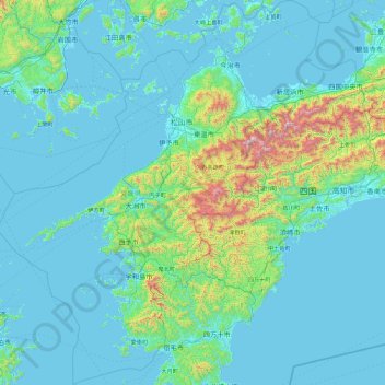
Name: Préfecture d'Ehime topographic map, elevation, terrain.
Location: Préfecture d'Ehime, Japon (32.78602 131.88036 34.32014 133.69280)
Average elevation: 172 m
Minimum elevation: -2 m
Maximum elevation: 1,883 m
Other topographic maps
Click on a map to view its topography, its elevation and its terrain.