
Make a donation
Gear up for your next adventure:
As an Amazon Associate, this site earns from qualifying purchases at no extra cost to you.
Angus topographic map
Click on the map to display elevation.
Make a donation
Gear up for your next adventure:
As an Amazon Associate, this site earns from qualifying purchases at no extra cost to you.
Angus
Angus can be split into three geographic areas. To the north and west, the topography is mountainous. This is the area of the Grampian Mountains, Mounth hills and Five Glens of Angus, which is sparsely populated and where the main industry is hill farming. Glas Maol – the highest point in Angus at 1,068 m (3,504 ft) – can be found here, on the tripoint boundary with Perthshire and Aberdeenshire. To the south and east the topography consists of rolling hills (such as the Sidlaws) bordering the sea; this area is well populated, with the larger towns. In between lies Strathmore (the Great Valley), which is a fertile agricultural area noted for the growing of potatoes, soft fruit and the raising of Aberdeen Angus cattle.
Make a donation
Gear up for your next adventure:
As an Amazon Associate, this site earns from qualifying purchases at no extra cost to you.
About this map
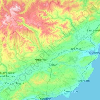
Name: Angus topographic map, elevation, terrain.
Location: Angus, Scotland, United Kingdom (56.46165 -3.40702 56.98681 -2.41855)
Average elevation: 254 m
Minimum elevation: 0 m
Maximum elevation: 1,144 m
Make a donation
Gear up for your next adventure:
As an Amazon Associate, this site earns from qualifying purchases at no extra cost to you.
Other topographic maps
Click on a map to view its topography, its elevation and its terrain.
Edinburgh
United Kingdom > Scotland > Edinburgh
Some have called Edinburgh the Athens of the North for a variety of reasons. The earliest comparison between the two cities showed that they had a similar topography, with the Castle Rock of Edinburgh performing a similar role to the Athenian Acropolis. Both of them had flatter, fertile agricultural land…
Average elevation: 104 m
Glasgow
United Kingdom > Scotland > Glasgow City
Glasgow itself was reputed to have been founded by the Christian missionary Saint Mungo in the 6th century. He established a church on the Molendinar Burn, where the present Glasgow Cathedral stands, and in the following years Glasgow became a religious centre. Glasgow grew over the following centuries. The…
Average elevation: 128 m
Ben Nevis
United Kingdom > Scotland > Highland
Ben Nevis has a highland (alpine) maritime (oceanic) polar climate (ET climate in the Köppen classification). Ben Nevis's elevation, maritime location and topography frequently lead to cool and cloudy weather conditions, which can pose a danger to ill-equipped walkers. According to the observations carried…
Average elevation: 912 m
Aberdeen
United Kingdom > Scotland > Aberdeen
Two weather stations collect climate data for the area, Aberdeen/Dyce Airport, and Craibstone. Both are about 4 1⁄2 miles (7 km) to the north west of the city centre, and given that they are in close proximity to each other, exhibit very similar climatic regimes. Dyce tends to have marginally warmer daytime…
Average elevation: 52 m
Make a donation
Gear up for your next adventure:
As an Amazon Associate, this site earns from qualifying purchases at no extra cost to you.
Make a donation
Gear up for your next adventure:
As an Amazon Associate, this site earns from qualifying purchases at no extra cost to you.
Elgin
United Kingdom > Scotland > Moray
Elgin is first documented in the Cartulary of Moray in 1190 AD. It was created a royal burgh in the 12th century by King David I of Scotland, and by that time had a castle on top of the present-day Lady Hill to the west of the town. The origin of the name Elgin is likely to be Celtic. It may derive from…
Average elevation: 26 m
Make a donation
Gear up for your next adventure:
As an Amazon Associate, this site earns from qualifying purchases at no extra cost to you.
Ben A'an
United Kingdom > Scotland > Stirling
Ben A'an is a hill in the Trossachs in Scotland. The pointed peak of its west top (454 metres or 1,490 feet in elevation) resembles a small mountain.
Average elevation: 283 m
Make a donation
Gear up for your next adventure:
As an Amazon Associate, this site earns from qualifying purchases at no extra cost to you.
Make a donation
Gear up for your next adventure:
As an Amazon Associate, this site earns from qualifying purchases at no extra cost to you.
Make a donation
Gear up for your next adventure:
As an Amazon Associate, this site earns from qualifying purchases at no extra cost to you.
Ailsa Craig
In a small glen above Ailsa Castle, a small freshwater body known as the Garry Loch is located at an altitude of 247 m (810 ft), with a depth of at least 17 feet.
Average elevation: 14 m
Make a donation
Gear up for your next adventure:
As an Amazon Associate, this site earns from qualifying purchases at no extra cost to you.
Mull of Kintyre
Ailsa Craig and the County Antrim coast of Ulster and Rathlin Island are all clearly visible from the Mull. On clearer days it is also possible to make out Malin Head in Inishowen in County Donegal in the west of Ulster, and the Ayrshire coast on the other side of Ailsa Craig. Other islands in the Firth of…
Average elevation: 84 m
Make a donation
Gear up for your next adventure:
As an Amazon Associate, this site earns from qualifying purchases at no extra cost to you.
Make a donation
Gear up for your next adventure:
As an Amazon Associate, this site earns from qualifying purchases at no extra cost to you.
Make a donation
Gear up for your next adventure:
As an Amazon Associate, this site earns from qualifying purchases at no extra cost to you.
Make a donation
Gear up for your next adventure:
As an Amazon Associate, this site earns from qualifying purchases at no extra cost to you.
Make a donation
Gear up for your next adventure:
As an Amazon Associate, this site earns from qualifying purchases at no extra cost to you.
Make a donation
Gear up for your next adventure:
As an Amazon Associate, this site earns from qualifying purchases at no extra cost to you.
Make a donation
Gear up for your next adventure:
As an Amazon Associate, this site earns from qualifying purchases at no extra cost to you.
Make a donation
Gear up for your next adventure:
As an Amazon Associate, this site earns from qualifying purchases at no extra cost to you.
Coatbridge
United Kingdom > Scotland > North Lanarkshire
The topography of Coatbridge was an important feature in the town's development during the industrial revolution. Coatbridge rests 60 metres below the "Slamannan plateau" and neighbouring Airdrie sits on its edge. The low-lying flat ground of Coatbridge was a vital factor in the siting of the town's blast…
Average elevation: 99 m
Airdrie
United Kingdom > Scotland > North Lanarkshire
Airdrie's name first appeared in the Register of the Great Seal of Scotland (Registrum Magni Sigilii Regum Scotorum) in 1373 as Ardre. By 1546 it had become Ardry and by 1587 it was known as Ardrie. In 1630 it finally appeared in the Register as Airdrie. Given the topography of the area, the most likely…
Average elevation: 135 m
Make a donation
Gear up for your next adventure:
As an Amazon Associate, this site earns from qualifying purchases at no extra cost to you.
Fort William
United Kingdom > Scotland > Highland
Fort William has an oceanic climate (Cfb) with moderate, but generally cool, temperatures and abundant precipitation. In the towns immediate vicinity, there are significant variations in elevation, which leads to some uninhabited areas near the town having a subpolar oceanic climate (Cfc), or, at the absolute…
Average elevation: 122 m
Pentland Hills Regional Park
United Kingdom > Scotland > Edinburgh > Peggyslea
Average elevation: 249 m
Make a donation
Gear up for your next adventure:
As an Amazon Associate, this site earns from qualifying purchases at no extra cost to you.
Culloden Battlefield
United Kingdom > Scotland > Highland > Newlands of Culloden > Leanach
Since 2001, the site of the battle has undergone topographic, geophysical and metal detector surveys in addition to archaeological excavations. Interesting finds have been made in the areas on which the fiercest fighting occurred on the government left wing, particularly where Barrell's and Dejean's regiments…
Average elevation: 141 m
Make a donation
Gear up for your next adventure:
As an Amazon Associate, this site earns from qualifying purchases at no extra cost to you.
Make a donation
Gear up for your next adventure:
As an Amazon Associate, this site earns from qualifying purchases at no extra cost to you.
Make a donation
Gear up for your next adventure:
As an Amazon Associate, this site earns from qualifying purchases at no extra cost to you.
Make a donation
Gear up for your next adventure:
As an Amazon Associate, this site earns from qualifying purchases at no extra cost to you.
Make a donation
Gear up for your next adventure:
As an Amazon Associate, this site earns from qualifying purchases at no extra cost to you.
Dundee
United Kingdom > Scotland > Dundee City
Dundee sits on the north bank of the Firth of Tay on the eastern, North Sea Coast of Scotland. The city lies 36.1 miles (58 km) NNE of Edinburgh and 360.6 miles (580 km) NNW of London. The built-up area occupies a roughly rectangular shape 8.3 miles (13 km) long by 2.5 miles (4 km) wide, aligned in an east to…
Average elevation: 82 m
Falkirk
United Kingdom > Scotland > Falkirk
Falkirk is located in an area of undulating topography between the Slamannan Plateau and the upper reaches of the Firth of Forth. The area to the north of Falkirk is part of the floodplain of the River Carron. Two tributaries of the River Carron - the East Burn and the West Burn flow through the town and form…
Average elevation: 69 m
Make a donation
Gear up for your next adventure:
As an Amazon Associate, this site earns from qualifying purchases at no extra cost to you.
Make a donation
Gear up for your next adventure:
As an Amazon Associate, this site earns from qualifying purchases at no extra cost to you.
Aberlour
United Kingdom > Scotland > Moray
According to the 1846 A Topographical Dictionary of Scotland, "This parish, formerly called Skirdustan, signifying, in the Gaelic tongue, 'the division of Dustan', its tutelary saint, derived its present name from its situation at the mouth of a noisy burn, which discharges itself into the river Spey."
Average elevation: 160 m
Make a donation
Gear up for your next adventure:
As an Amazon Associate, this site earns from qualifying purchases at no extra cost to you.