Geolocate

Gartloch topographic map

Click on the map to display elevation.

About this map

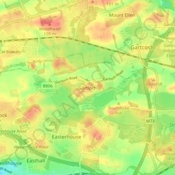
Name: Gartloch topographic map, elevation, terrain.

Location: Gartloch, Glasgow City, Scotland, G69 8FD, United Kingdom (55.85948 -4.12496 55.89948 -4.08496)

Average elevation: 85 m

Minimum elevation: 57 m

Maximum elevation: 107 m

Other topographic maps

Click on a map to view its topography, its elevation and its terrain.

Glasgow Green

United Kingdom > Scotland > Glasgow City > Glasgow

Average elevation: 14 m

Cathkin Park

United Kingdom > Scotland > Glasgow City > Glasgow

Average elevation: 26 m

Linn Park

United Kingdom > Scotland > Glasgow City > Glasgow

Average elevation: 65 m

Queen's Park

United Kingdom > Scotland > Glasgow City > Glasgow

Average elevation: 28 m

Cathkin Park

United Kingdom > Scotland > Glasgow City > Glasgow

Average elevation: 26 m

Gear up for your next adventure:

🚲MTB Frame Bag - Carry tools and maps directly on your bicycle frame
Backpacking Tent - Lightweight tent for long-distance hiking trips
🦶Anti-Blister Balm - Prevents friction and hotspots during long ascents
Bushcraft Tarp - Versatile emergency shelter or gear protection
🧴Insect Repellent - Protect yourself from bugs during outdoor adventures

As an Amazon Associate, this site earns from qualifying purchases at no extra cost to you.