Geolocate

Kingussie topographic map

Click on the map to display elevation.

About this map

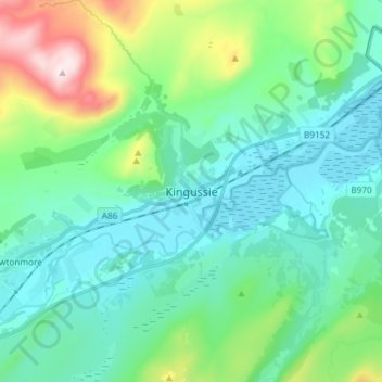
Name: Kingussie topographic map, elevation, terrain.

Location: Kingussie, Highland, Scotland, PH21 1LG, United Kingdom (57.04028 -4.09116 57.12028 -4.01116)

Average elevation: 338 m

Minimum elevation: 215 m

Maximum elevation: 781 m

Other topographic maps

Click on a map to view its topography, its elevation and its terrain.

Loch Ness

United Kingdom > Scotland > Highland > Dores

Average elevation: 340 m

Gear up for your next adventure:

🧭Orienteering Kit - Tools for map reading and navigation in the wild
🧣Merino Neck Gaiter - Protects against wind, sun, and cold at high altitudes
🥾Trail Running Shoes - Lightweight and durable shoes for trail running
🥾Hiking Gaiters - Protect legs and shoes from mud, snow, and debris
📷Outdoor Action Camera - Capture high-elevation views and rugged adventures

As an Amazon Associate, this site earns from qualifying purchases at no extra cost to you.