Geolocate

St Andrews topographic map

Click on the map to display elevation.

About this map

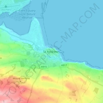
Name: St Andrews topographic map, elevation, terrain.

Location: St Andrews, Fife, Scotland, KY16 9PA, United Kingdom (56.30039 -2.83558 56.38039 -2.75558)

Average elevation: 38 m

Minimum elevation: -1 m

Maximum elevation: 174 m

Gear up for your next adventure:

🚑Survival Whistle - Signal for help across long distances in mountains
🧰Survival Kit - Essential gear for emergencies in the wilderness
🥾Hiking Boots - Sturdy boots providing ankle support and traction on rugged trails
💧Hydration Pack - Hands-free hydration system for long hikes
🧥Waterproof Pants - Keep dry during rainy hiking conditions

As an Amazon Associate, this site earns from qualifying purchases at no extra cost to you.