
Make a donation
Gear up for your next adventure:
As an Amazon Associate, this site earns from qualifying purchases at no extra cost to you.
Calanque d'En-Vau topographic map
Click on the map to display elevation.
Make a donation
Gear up for your next adventure:
As an Amazon Associate, this site earns from qualifying purchases at no extra cost to you.
About this map
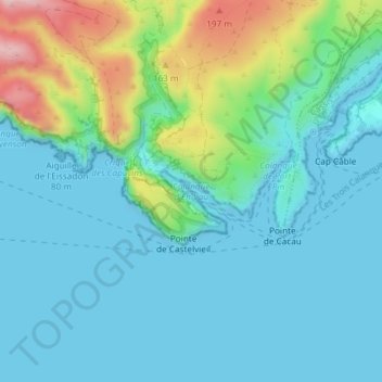
Name: Calanque d'En-Vau topographic map, elevation, terrain.
Location: Calanque d'En-Vau, Metropolitan France, 13260, France (43.20092 5.50103 43.20102 5.50113)
Average elevation: 52 m
Minimum elevation: -2 m
Maximum elevation: 244 m
Make a donation
Gear up for your next adventure:
As an Amazon Associate, this site earns from qualifying purchases at no extra cost to you.
Other topographic maps
Click on a map to view its topography, its elevation and its terrain.
Paris
France > Ile-de-France > Paris
Paris in its early history had only the rivers Seine and Bièvre for water. From 1809, the Canal de l'Ourcq provided Paris with water from less-polluted rivers to the north-east of the capital. From 1857, the civil engineer Eugène Belgrand, under Napoleon III, oversaw the construction of a series of new…
Average elevation: 62 m
Toulouse
France > Occitania > Haute-Garonne
The first half of the 14th century was a prosperous period, despite the dismemberment in 1317 of the very large bishopric of Toulouse (which lost two thirds of its area and a large part of its income, a loss only partially compensated by its elevation to the rank of archbishopric), and the episode of the…
Average elevation: 155 m
Make a donation
Gear up for your next adventure:
As an Amazon Associate, this site earns from qualifying purchases at no extra cost to you.
Réserve naturelle des Aiguilles rouges
France > Auvergne-Rhône-Alpes > Upper Savoy > Chamonix-Mont-Blanc
Average elevation: 1,951 m
Make a donation
Gear up for your next adventure:
As an Amazon Associate, this site earns from qualifying purchases at no extra cost to you.
Chamonix-Mont-Blanc
France > Auvergne-Rhône-Alpes > Upper Savoy
Due to its elevation, Chamonix has a humid continental climate (Dfb, according to the Köppen climate classification), with an average annual precipitation of 1,280 mm (50 in). Summers are mild and winters are cold and snowy.
Average elevation: 2,215 m
Saint Barthélemy
Morne de Vitet, 286 metres (938 feet) in height, is the highest peak on the island. Hills and valleys of varying topography cover the rest of the island. Notable are Morne Rouge, Morne Criquet, Morne de Grand Fond, Morne de Dépoudré and Morne Lurin. The largest bodies of water on the island are Étang de…
Average elevation: 4 m
Ardennes
Covering 5,229 square kilometres (2,019 square miles), the department was the smallest among the four contributors to Champagne-Ardenne. It is diverse in climate, topography, natural vegetation and land use, which is a mixture of forest and arable farming.
Average elevation: 225 m
Make a donation
Gear up for your next adventure:
As an Amazon Associate, this site earns from qualifying purchases at no extra cost to you.
Nantes
France > Pays de la Loire > Loire-Atlantique
Nantes is built on the Armorican Massif, a range of weathered mountains which may be considered the backbone of Brittany. The mountains, stretching from the end of the Breton peninsula to the outskirts of the sedimentary Paris Basin, are composed of several parallel ridges of Ordovician and Cadomian rocks.…
Average elevation: 26 m
Make a donation
Gear up for your next adventure:
As an Amazon Associate, this site earns from qualifying purchases at no extra cost to you.
Versailles
France > Ile-de-France > Yvelines
Versailles is located 17.1 km (10.6 mi) west-southwest from the centre of Paris. The city sits on an elevated plateau, 130 to 140 metres (425 to 460 ft) above sea-level (whereas the elevation of the centre of Paris is only 33 m (108 ft) above sea level), surrounded by wooded hills: in the north the forests of…
Average elevation: 142 m
Brittany
France > Brittany > Landerneau > Loudéac
The Armorican massif reaches its maximal elevation outside of Brittany, in neighbouring Mayenne, at 417 m, and slopes towards the west before straightening on its western extremity, with the Montagnes Noires and the Monts d'Arrée. The highest hill in Brittany is the Roc'h Ruz in the Monts d'Arrée, at 385 m…
Average elevation: 50 m
Annecy
France > Auvergne-Rhône-Alpes > Annecy
Annecy has an oceanic climate (Köppen Cfb) in spite of its relatively far inland position. Influenced by its elevation, summers are rather moderate on average, although they can be highly variable with extreme heat spikes. Winters see occasional freezing temperatures, but most often stays in the single-digits…
Average elevation: 554 m
Make a donation
Gear up for your next adventure:
As an Amazon Associate, this site earns from qualifying purchases at no extra cost to you.
Lavoûte-Chilhac
France > Auvergne-Rhône-Alpes > Haute-Loire
The village is located at an altitude of over 400 meters.
Average elevation: 566 m
Valence
France > Auvergne-Rhône-Alpes > Drôme
The area of the commune is 3,669 hectares (9,070 acres), representing 36.69 square kilometres (14.17 sq mi); the altitude varies between 106–191 metres (348–627 ft).
Average elevation: 151 m
Make a donation
Gear up for your next adventure:
As an Amazon Associate, this site earns from qualifying purchases at no extra cost to you.
Paris
Paris is situated on a relatively flat terrain, with its average elevation around 150 feet (45 meters) above sea level. The city lies within the Paris Basin, a low-lying area that was shaped over millennia by the meandering River Seine, which cuts through the city. Though generally flat, Paris is home to…
Average elevation: 59 m
Saint-Gervais-les-Bains
France > Auvergne-Rhône-Alpes > Upper Savoy
The main railway station for Saint-Gervais is the Gare de Saint-Gervais-les-Bains-Le Fayet. The Mont Blanc Tramway departs from the forecourt of Le Fayet station and reaches the Nid d'Aigle station at the Bionnassay glacier at an altitude of 2,372 m (7,782 ft). The Saint-Gervais–Vallorcine railway, a metre…
Average elevation: 1,589 m
Make a donation
Gear up for your next adventure:
As an Amazon Associate, this site earns from qualifying purchases at no extra cost to you.
Make a donation
Gear up for your next adventure:
As an Amazon Associate, this site earns from qualifying purchases at no extra cost to you.
Albertville
France > Auvergne-Rhône-Alpes > Savoy
Albertville is situated on the river Arly, close to the confluence with the river Isère. Its altitude ranges from 345 to 2,037 metres (1,132 to 6,683 ft). Nearby mountains include: Belle Étoile, Dent de Cons, Négresse, Roche Pourrie, Mirantin, Pointe de la Grande Journée, Chaîne du Grand Arc. Nearby…
Average elevation: 595 m
Make a donation
Gear up for your next adventure:
As an Amazon Associate, this site earns from qualifying purchases at no extra cost to you.
Annecy
France > Auvergne-Rhône-Alpes > Upper Savoy
Annecy has an oceanic climate (Köppen: Cfb) despite its relatively far inland position. Influenced by its elevation, summers are rather moderate on average, although they can be highly variable with extreme heat spikes. Winters see occasional freezing temperatures, but temperatures most often stay in the…
Average elevation: 610 m
Make a donation
Gear up for your next adventure:
As an Amazon Associate, this site earns from qualifying purchases at no extra cost to you.
Corsica
Under the Köppen climate classification scheme, coastal regions are characterized by a hot-summer Mediterranean climate (Csa). Further inland, a warm-summer Mediterranean climate (Csb) is more common. At the highest elevation locations, small areas with a subarctic climate (Dsc, Dfc) and the rare cold-summer…
Average elevation: 139 m
Lourdes
France > Occitania > Hautes Pyrenees
Lourdes lies at an elevation of 420 m (1,380 ft) and in a central position through which runs the fast-flowing river Gave de Pau from the south, coming from its source at Gavarnie; into it flow several smaller rivers from Barèges and Cauterets. The Gave then branches off to the west towards the Béarn,…
Average elevation: 514 m
Make a donation
Gear up for your next adventure:
As an Amazon Associate, this site earns from qualifying purchases at no extra cost to you.
Make a donation
Gear up for your next adventure:
As an Amazon Associate, this site earns from qualifying purchases at no extra cost to you.
Make a donation
Gear up for your next adventure:
As an Amazon Associate, this site earns from qualifying purchases at no extra cost to you.
Guadeloupe
The two main islands are Basse-Terre (west) and Grande-Terre (east), which form a butterfly shape as viewed from above, the two 'wings' of which are separated by the Grand Cul-de-Sac Marin, Rivière Salée [fr] and Petit Cul-de-Sac Marin. More than half of Guadeloupe's land surface consists of the 847.8 km2…
Average elevation: 18 m
Make a donation
Gear up for your next adventure:
As an Amazon Associate, this site earns from qualifying purchases at no extra cost to you.
Make a donation
Gear up for your next adventure:
As an Amazon Associate, this site earns from qualifying purchases at no extra cost to you.
Make a donation
Gear up for your next adventure:
As an Amazon Associate, this site earns from qualifying purchases at no extra cost to you.
Le Puy-en-Velay
France > Auvergne-Rhône-Alpes > Haute-Loire
Because of its altitude, Le Puy is close to a warm-summer humid continental climate (Dfb) under the Köppen system but still remains oceanic (Cfb) due to its coldest month, slightly above freezing on average. The city is prone to mountain cold in winter, with at least four months with average lows below…
Average elevation: 737 m
Make a donation
Gear up for your next adventure:
As an Amazon Associate, this site earns from qualifying purchases at no extra cost to you.
Make a donation
Gear up for your next adventure:
As an Amazon Associate, this site earns from qualifying purchases at no extra cost to you.
Make a donation
Gear up for your next adventure:
As an Amazon Associate, this site earns from qualifying purchases at no extra cost to you.
Make a donation
Gear up for your next adventure:
As an Amazon Associate, this site earns from qualifying purchases at no extra cost to you.
Make a donation
Gear up for your next adventure:
As an Amazon Associate, this site earns from qualifying purchases at no extra cost to you.
Make a donation
Gear up for your next adventure:
As an Amazon Associate, this site earns from qualifying purchases at no extra cost to you.
Make a donation
Gear up for your next adventure:
As an Amazon Associate, this site earns from qualifying purchases at no extra cost to you.
Make a donation
Gear up for your next adventure:
As an Amazon Associate, this site earns from qualifying purchases at no extra cost to you.
Make a donation
Gear up for your next adventure:
As an Amazon Associate, this site earns from qualifying purchases at no extra cost to you.