Geolocate

Montgeron topographic map

Click on the map to display elevation.

About this map
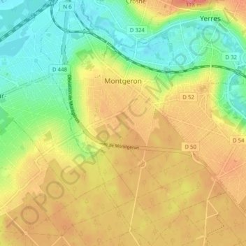
Name: Montgeron topographic map, elevation, terrain.

Location: Montgeron, Évry, Essonne, Ile-de-France, Metropolitan France, 91230, France (48.66962 2.43451 48.72064 2.49323)

Average elevation: 68 m

Minimum elevation: 31 m

Maximum elevation: 106 m

Other topographic maps

Click on a map to view its topography, its elevation and its terrain.

Paris Basin

France > Ile-de-France > Essonne > Bièvres

The landscape is one of very broad valleys (flood plains), modest watershed hills and well-drained plateaux of comparatively little altitude. In the south-east and east the plain of Champagne and the Seuil de Bourgogne (Threshold of Burgundy) differential erosion of the strata has left low scarps with the dip…

Average elevation: 126 m

La Roche

France > Ile-de-France > Essonne

Average elevation: 91 m

Gear up for your next adventure:

🧊Insulated Water Bottle - Keeps drinks cold in summer and prevents freezing in winter
🥾Approach Shoes - Shoes designed for climbing approaches and rugged trails
🧤Thermal Hiking Gloves - Grip-enhanced gloves for cold-weather altitude trekking
🥾Trail Running Boots - Durable shoes designed for trail running
🧢Outdoor Cap - Protective cap for sun and rain during hikes

As an Amazon Associate, this site earns from qualifying purchases at no extra cost to you.