Geolocate

Réunion topographic map

Click on the map to display elevation.

About this map
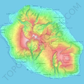
Name: Réunion topographic map, elevation, terrain.

Location: Réunion, France (-21.38973 55.21643 -20.87171 55.83669)

Average elevation: 532 m

Minimum elevation: 0 m

Maximum elevation: 3,043 m

Other topographic maps

Click on a map to view its topography, its elevation and its terrain.
Boucan-Canot

France > Réunion > Saint-Paul

Average elevation: 41 m

Ravine-Glissante

France > Réunion > Sainte-Rose

Average elevation: 87 m

La Rivière des Galets

France > Réunion > Le Port

Average elevation: 106 m

Saint-Laurent

France > Réunion > La Possession

Average elevation: 126 m

Ruisseau Blanc

France > Réunion > Saint-Denis

Average elevation: 385 m

Grand Bassin

France > Réunion > Le Tampon

Average elevation: 1,179 m

La Plaine Chabrier

France > Réunion > Saint-Paul

Average elevation: 26 m

Hell-Bourg

France > Réunion

Average elevation: 1,132 m

Gear up for your next adventure:

⛺Camping Essentials - All-in-one gear for a comfortable camping trip
🛰️Satellite Messenger - Emergency communication for areas with no cell service
💡LED Camping Lantern - Illuminate your campsite with long-lasting lanterns
🥾Mountaineering Boots - Supportive boots for climbing and high-altitude hiking
🚲MTB Frame Bag - Carry tools and maps directly on your bicycle frame

As an Amazon Associate, this site earns from qualifying purchases at no extra cost to you.