Geolocate

Socorro County topographic map

Interactive map

Click on the map to display elevation.

Socorro County

A mining rush followed the Apache wars – gold, silver, and copper were found in the mountains. It wasn't until this time that extensive use of the area by non-Native Americans occurred. While some mining activity, involving gold, silver, and copper, occurred in the southern part of the range near the end of the nineteenth century, the prospecting/mining remnants are barely visible today due to collapse, topographic screening, and vegetation regrowth. While miners combed the mountains for mineral riches during the late nineteenth and early twentieth centuries, stockmen drove tens of thousands of sheep and cattle to stockyards at the village of Magdalena, then linked by rail with Socorro. In fact, the last regularly used cattle trail in the United States stretched 125 miles westward from Magdalena. The route was formally known as the Magdalena Livestock Driveway, but more popularly known to cowboys and cattlemen as the Beefsteak Trail. The trail began use in 1865 and its peak was in 1919. The trail was used continually until trailing gave way to trucking and the trail officially closed in 1971.

Wikipedia (CC-BY-SA 3.0)

About this map

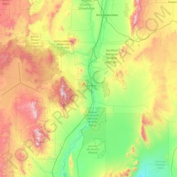
Name: Socorro County topographic map, elevation, terrain.

Location: Socorro County, New Mexico, United States (33.47528 -107.72672 34.58061 -105.92378)

Average elevation: 1,830 m

Minimum elevation: 1,238 m

Maximum elevation: 3,190 m

Other topographic maps

Click on a map to view its topography, its elevation and its terrain.

Farmington

United States > New Mexico > San Juan County

Farmington has a semi-arid climate. Despite its altitude of 5,473 feet (1,668 m), the city can experience hot summers and cold winters with low precipitation throughout the year. The average annual snowfall is 12.3 inches (31 cm).

Average elevation: 1,698 m

Cuchillo

United States > New Mexico > Sierra County

Average elevation: 1,508 m

Santa Fe

United States > New Mexico > Santa Fe County

Santa Fe (/ˌsæntə ˈfeɪ, ˈsæntə feɪ/ SAN-tə FAY, -⁠ fay; Spanish: [santaˈfe]) is the capital of the U.S. state of New Mexico, and the county seat of Santa Fe County. With over 89,000 residents, Santa Fe is the fourth-most populous city in the state, and part of the Albuquerque–Santa Fe–Los…

Average elevation: 2,221 m

Pep

United States > New Mexico > Roosevelt County

Average elevation: 1,294 m

Las Cruces

United States > New Mexico > Doña Ana County

The approximate elevation of Las Cruces is 3,908 feet (1,191 m) above sea level.

Average elevation: 1,297 m

Rio Rancho

United States > New Mexico > Sandoval County

Rio Rancho is in an arid climate due to its location in the rain shadow of the Sandia Mountains to the east and the Continental Divide to the west. Rio Rancho receives 8.90 inches of precipitation annually on average. The western portion of the city receives slightly more rain and snowfall due to its higher…

Average elevation: 1,672 m

Las Vegas

United States > New Mexico > San Miguel County

Average elevation: 1,994 m

Artesia

United States > New Mexico > Eddy County

Average elevation: 1,037 m

Medanales

United States > New Mexico > Rio Arriba County

Average elevation: 1,804 m

San Francisco

United States > New Mexico > Catron County

Average elevation: 2,440 m

Portales

United States > New Mexico > Roosevelt County

Average elevation: 1,225 m

San Miguel County

United States > New Mexico

Average elevation: 1,851 m

Sierra County

United States > New Mexico

Average elevation: 1,679 m

San Juan County

United States > New Mexico

Average elevation: 1,889 m

Devils Monument

United States > New Mexico > Catron County

Average elevation: 2,251 m

Bosque Farms

United States > New Mexico > Valencia County

Average elevation: 1,485 m

White Oaks

United States > New Mexico > Lincoln County

Average elevation: 2,001 m

El Prado

United States > New Mexico > Taos County

Average elevation: 2,145 m

Espanola

United States > New Mexico > Santa Fe County

Española lies at an elevation of around 5,595 feet (1,705 m) with much variance. It is in a valley nestled between the Jemez and Sangre de Cristo mountain ranges, and the meeting point of three rivers, the Rio Grande, the Rio Chama, and the Rio Santa Cruz.

Average elevation: 1,739 m

Otero County

United States > New Mexico

Average elevation: 1,595 m

Corona

United States > New Mexico > Lincoln County

Average elevation: 2,055 m

McGaffey

United States > New Mexico > McKinley County

Average elevation: 2,412 m

Chaves County

United States > New Mexico

Average elevation: 1,352 m

Rancho Viejo

United States > New Mexico > Santa Fe County

Average elevation: 1,994 m

Lea County

United States > New Mexico

Average elevation: 1,100 m

Cibola County

United States > New Mexico

Average elevation: 2,124 m

Lincoln County

United States > New Mexico

Average elevation: 1,761 m

Grants

United States > New Mexico > Cibola County

Average elevation: 2,019 m

Catron County

United States > New Mexico

Average elevation: 2,231 m

Ruidoso

United States > New Mexico > Lincoln County

Ruidoso is in southern Lincoln County, with elevations ranging from 6,400 feet (2,000 m) at the village's southeast corner in the valley of the Rio Ruidoso up to over 7,700 feet (2,300 m) at the village's northern end near Alto. Ruidoso's southern border and westernmost border follow the Otero County line. The…

Average elevation: 2,287 m

Torreon

United States > New Mexico > Sandoval County

Average elevation: 1,984 m

Alamogordo

United States > New Mexico > Otero County > Alamogordo

As of 2010, Alamogordo had a total area of 19.3 square miles (50.0 km2), all land. The city is located at an elevation of 4,330 feet (1,320 m) on the western flank of the Sacramento Mountains and on the eastern edge of the Tularosa Basin. It lies within the Rio Grande rift and in the northernmost part of the…

Average elevation: 1,716 m

Albuquerque

United States > New Mexico > Bernalillo County > Albuquerque

Located in north-central New Mexico, Albuquerque serves as the county seat of Bernalillo County. To its east are the Sandia–Manzano Mountains, Rio Grande flows north to south through its center, while the West Mesa and Petroglyph National Monument make up the western part of the city. Albuquerque has one of…

Average elevation: 1,671 m

Tokay

United States > New Mexico > Socorro County > Tokay

Average elevation: 1,546 m

Albuquerque

United States > New Mexico > Bernalillo County

Albuquerque serves as the county seat of Bernalillo County, and is in north-central New Mexico. The Sandia Mountains run along the eastern side of Albuquerque, and the Rio Grande flows north to south through its center, while the West Mesa and Petroglyph National Monument make up the western part of the city.…

Average elevation: 1,688 m

La Madera

United States > New Mexico > Sandoval County > La Madera

Average elevation: 2,166 m

Taos

United States > New Mexico > Taos County > Taos

Average elevation: 2,173 m

Sunshine Valley

United States > New Mexico > Taos County

Average elevation: 2,278 m

Taos

United States > New Mexico > Taos County

The elevation of the town is 6,969 feet (2,124 m). Just north of Taos is Wheeler Peak, at 13,161 feet (4,011 m), the highest point in New Mexico. Taos has a warm-summer humid continental climate (Köppen Dfb), though it borders on a semi-arid climate (BSk) due to the low rainfall. The town is characterized by…

Average elevation: 2,180 m

Baylor Canyon

United States > New Mexico

Average elevation: 1,758 m

Baldy Mountain

United States > New Mexico

Average elevation: 3,437 m

Mayhill

United States > New Mexico > Otero County

Average elevation: 2,104 m