
Make a donation
Gear up for your next adventure:
As an Amazon Associate, this site earns from qualifying purchases at no extra cost to you.
Baldy Mountain topographic map
Click on the map to display elevation.
Make a donation
Gear up for your next adventure:
As an Amazon Associate, this site earns from qualifying purchases at no extra cost to you.
About this map
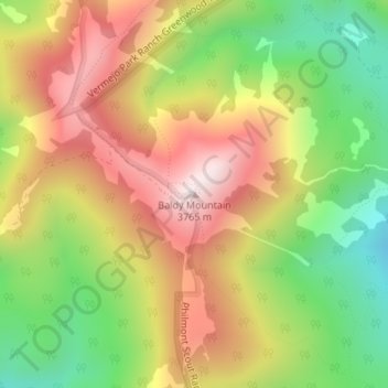
Name: Baldy Mountain topographic map, elevation, terrain.
Location: Baldy Mountain, Colfax County, New Mexico, United States (36.62973 -105.21324 36.62983 -105.21314)
Average elevation: 3,437 m
Minimum elevation: 3,089 m
Maximum elevation: 3,786 m
Make a donation
Gear up for your next adventure:
As an Amazon Associate, this site earns from qualifying purchases at no extra cost to you.
Other topographic maps
Click on a map to view its topography, its elevation and its terrain.
Silver City
United States > New Mexico > Grant County
During the period from 1901 to 1964, when readings were taken at the city center (which is cooler and wetter than outlying and lower-elevation districts nearby), the coldest temperature recorded was −13 °F (−25 °C) on January 11, 1962, and the hottest 105 °F (40.6 °C) on July 5, 1901. The coldest month…
Average elevation: 1,851 m
Farmington
United States > New Mexico > San Juan County
Farmington has a semi-arid climate. Despite its altitude of 5,473 feet (1,668 m), the city can experience hot summers and cold winters with low precipitation throughout the year. The average annual snowfall is 12.3 inches (31 cm).
Average elevation: 1,698 m
Make a donation
Gear up for your next adventure:
As an Amazon Associate, this site earns from qualifying purchases at no extra cost to you.
Socorro County
A mining rush followed the Apache wars – gold, silver, and copper were found in the mountains. It wasn't until this time that extensive use of the area by non-Native Americans occurred. While some mining activity, involving gold, silver, and copper, occurred in the southern part of the range near the end of…
Average elevation: 1,830 m
Make a donation
Gear up for your next adventure:
As an Amazon Associate, this site earns from qualifying purchases at no extra cost to you.
City of Rocks State Park
United States > New Mexico > Grant County
The City of Rocks State Park is also home to two main hiking trails: the Hydra trail, the Table Mountain trail, and the newly added Cienega Trail. The Hydra trail is 3.3 miles long with an elevation gain of 164ft. The Table Mountain trail is 3 miles long with an elevation gain of 695 ft. And the Cienega is…
Average elevation: 1,596 m
Make a donation
Gear up for your next adventure:
As an Amazon Associate, this site earns from qualifying purchases at no extra cost to you.
Make a donation
Gear up for your next adventure:
As an Amazon Associate, this site earns from qualifying purchases at no extra cost to you.
Taos
United States > New Mexico > Taos County
The elevation of the town is 6,969 feet (2,124 m). Just north of Taos is Wheeler Peak, at 13,161 feet (4,011 m), the highest point in New Mexico. Taos has a warm-summer humid continental climate (Köppen Dfb), though it borders on a semi-arid climate (BSk) due to the low rainfall. The town is characterized by…
Average elevation: 2,180 m
Make a donation
Gear up for your next adventure:
As an Amazon Associate, this site earns from qualifying purchases at no extra cost to you.