
Make a donation
Gear up for your next adventure:
As an Amazon Associate, this site earns from qualifying purchases at no extra cost to you.
Alamogordo topographic map
Click on the map to display elevation.
Make a donation
Gear up for your next adventure:
As an Amazon Associate, this site earns from qualifying purchases at no extra cost to you.
Alamogordo
As of 2010, Alamogordo had a total area of 19.3 square miles (50.0 km2), all land. The city is located at an elevation of 4,330 feet (1,320 m) on the western flank of the Sacramento Mountains and on the eastern edge of the Tularosa Basin. It lies within the Rio Grande rift and in the northernmost part of the Chihuahuan Desert.: 36 Tectonic activity is low in the Tularosa Basin. Plants native to the area are typical of the southern New Mexico foothills and include creosote bush, mesquite, saltbush, cottonwood, desert willow, and many species of cactus and yucca.
Make a donation
Gear up for your next adventure:
As an Amazon Associate, this site earns from qualifying purchases at no extra cost to you.
About this map
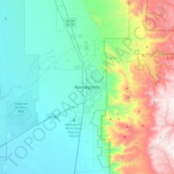
Name: Alamogordo topographic map, elevation, terrain.
Location: Alamogordo, Otero County, New Mexico, 88310, United States (32.74465 -106.10184 33.06465 -105.78184)
Average elevation: 1,716 m
Minimum elevation: 1,217 m
Maximum elevation: 2,945 m
Make a donation
Gear up for your next adventure:
As an Amazon Associate, this site earns from qualifying purchases at no extra cost to you.