
Make a donation
Gear up for your next adventure:
As an Amazon Associate, this site earns from qualifying purchases at no extra cost to you.
Catron County topographic map
Click on the map to display elevation.
Make a donation
Gear up for your next adventure:
As an Amazon Associate, this site earns from qualifying purchases at no extra cost to you.
About this map
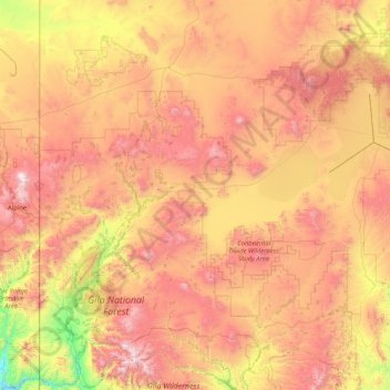
Name: Catron County topographic map, elevation, terrain.
Location: Catron County, New Mexico, United States (33.19898 -109.04747 34.58097 -107.71135)
Average elevation: 2,231 m
Minimum elevation: 1,330 m
Maximum elevation: 3,323 m
Make a donation
Gear up for your next adventure:
As an Amazon Associate, this site earns from qualifying purchases at no extra cost to you.
Other topographic maps
Click on a map to view its topography, its elevation and its terrain.
Albuquerque
United States > New Mexico > Bernalillo County > Albuquerque
Located in north-central New Mexico, Albuquerque serves as the county seat of Bernalillo County. To its east are the Sandia–Manzano Mountains, Rio Grande flows north to south through its center, while the West Mesa and Petroglyph National Monument make up the western part of the city. Albuquerque has one of…
Average elevation: 1,671 m
Alamogordo
United States > New Mexico > Otero County > Alamogordo
As of 2010, Alamogordo had a total area of 19.3 square miles (50.0 km2), all land. The city is located at an elevation of 4,330 feet (1,320 m) on the western flank of the Sacramento Mountains and on the eastern edge of the Tularosa Basin. It lies within the Rio Grande rift and in the northernmost part of the…
Average elevation: 1,716 m
Make a donation
Gear up for your next adventure:
As an Amazon Associate, this site earns from qualifying purchases at no extra cost to you.
City of Rocks State Park
United States > New Mexico > Grant County
The City of Rocks State Park is also home to two main hiking trails: the Hydra trail, the Table Mountain trail, and the newly added Cienega Trail. The Hydra trail is 3.3 miles long with an elevation gain of 164ft. The Table Mountain trail is 3 miles long with an elevation gain of 695 ft. And the Cienega is…
Average elevation: 1,596 m
Make a donation
Gear up for your next adventure:
As an Amazon Associate, this site earns from qualifying purchases at no extra cost to you.
Make a donation
Gear up for your next adventure:
As an Amazon Associate, this site earns from qualifying purchases at no extra cost to you.
Make a donation
Gear up for your next adventure:
As an Amazon Associate, this site earns from qualifying purchases at no extra cost to you.