
Stoke-on-Trent topographic map
Interactive map
Click on the map to display elevation.
About this map
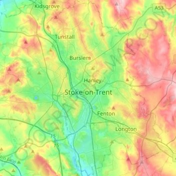
Name: Stoke-on-Trent topographic map, elevation, terrain.
Location: Stoke-on-Trent, England, United Kingdom (52.94619 -2.23876 53.09270 -2.07924)
Average elevation: 168 m
Minimum elevation: 92 m
Maximum elevation: 277 m
In 1919, the borough proposed to expand further and annex the neighbouring borough of Newcastle-under-Lyme and the Wolstanton United Urban District, both to the west of Stoke. This never took place, due to strong objections from Newcastle Corporation. A further attempt was made in 1930, with the promotion of the Stoke-on-Trent Extension Bill. Ultimately, Wolstanton was instead added to Newcastle-under-Lyme in 1932. Although attempts to take Newcastle, Wolstanton and Kidsgrove (north of Tunstall) were never successful, the borough did expand in 1922, taking in Smallthorne Urban District and parts of other parishes from Stoke upon Trent Rural District. The borough was officially granted city status in 1925, with a lord mayor from 1928. When the county borough of Stoke-on-Trent initially applied for city status in 1925, citing its importance as the centre of the pottery industry, it was refused by the Home Office as it had fewer than 300,000 inhabitants. The decision was overturned, however, when a direct approach was made to King George V, who agreed that the borough ought to be a city. The public announcement of the elevation to city status was made by the king during a visit to Stoke on 4 June 1925.
Other topographic maps
Click on a map to view its topography, its elevation and its terrain.
Random
United Kingdom > England > Random
Random, Shropshire, West Midlands, England, DY14 0QD, United Kingdom
Average elevation: 347 m
Water Houses
United Kingdom > England > North Yorkshire
Water Houses, Malham Moor, North Yorkshire, England, BD24 9PT, United Kingdom
Average elevation: 431 m
Dalton Moor
United Kingdom > England > North Yorkshire > Dalton
Dalton Moor, Dalton, North Yorkshire, England, YO7 3JD, United Kingdom
Average elevation: 27 m
Hornton
United Kingdom > England > Oxfordshire > Cherwell District
Hornton, Cherwell District, Oxfordshire, England, United Kingdom
Average elevation: 172 m
Billingham
United Kingdom > England > Stockton-on-Tees
Billingham, Stockton-on-Tees, Tees Valley, England, United Kingdom
Average elevation: 21 m
Bucks Green
United Kingdom > England > West Sussex > Horsham
Bucks Green, Horsham, West Sussex, England, RH12 3JN, United Kingdom
Average elevation: 47 m
Weybridge
United Kingdom > England > Surrey > Elmbridge
Weybridge, Elmbridge, Surrey, England, KT13 8RT, United Kingdom
Average elevation: 21 m
Syleham
United Kingdom > England > Suffolk > Mid Suffolk
Syleham, Mid Suffolk, Suffolk, England, United Kingdom
Average elevation: 40 m
Hodge Hill
United Kingdom > England > Birmingham
Hodge Hill, Birmingham, West Midlands Combined Authority, England, B36 8EG, United Kingdom
Average elevation: 101 m
London
United Kingdom > England > London
London, Westminster, England, SW1A 2DX, United Kingdom
Average elevation: 42 m
Bawsey
United Kingdom > England > Norfolk > King's Lynn and West Norfolk
Bawsey, King's Lynn and West Norfolk, Norfolk, England, United Kingdom
Average elevation: 16 m
Rotherham
Rotherham, South Yorkshire, England, United Kingdom
Average elevation: 101 m
Stockton-on-the-Forest
United Kingdom > England > York
Stockton-on-the-Forest, York, England, United Kingdom
Average elevation: 22 m
Waddington
United Kingdom > England > Lancashire > Ribble Valley
Waddington, Ribble Valley, Lancashire, England, United Kingdom
Average elevation: 164 m
St Helens
St Helens, Liverpool City Region, England, United Kingdom
Average elevation: 49 m
Blackburn
United Kingdom > England > Blackburn with Darwen
Blackburn, Blackburn with Darwen, England, BB1 7DP, United Kingdom
Average elevation: 157 m
Walton-on-Thames
United Kingdom > England > Surrey
Walton-on-Thames, Surrey, England, United Kingdom
Average elevation: 17 m
Nuneaton and Bedworth
United Kingdom > England > Warwickshire
Nuneaton and Bedworth, Warwickshire, England, United Kingdom
Average elevation: 108 m
Warmley
United Kingdom > England > South Gloucestershire
Warmley, Siston, South Gloucestershire, West of England, England, BS15 4PP, United Kingdom
Average elevation: 69 m
Bury St Edmunds
United Kingdom > England > Suffolk > West Suffolk
Bury St Edmunds, West Suffolk, Suffolk, England, United Kingdom
Average elevation: 54 m
Shepton Mallet
United Kingdom > England > Somerset
Shepton Mallet, Somerset, England, United Kingdom
Average elevation: 173 m
Brabourne Lees
United Kingdom > England > Kent > Ashford
Brabourne Lees, Ashford, Kent, England, TN25 6QG, United Kingdom
Average elevation: 73 m
Wadhurst
United Kingdom > England > East Sussex > Wealden
Wadhurst, Wealden, East Sussex, England, United Kingdom
Average elevation: 109 m
Upper Tean
United Kingdom > England > Staffordshire > Staffordshire Moorlands
Upper Tean, Staffordshire Moorlands, Staffordshire, England, ST10 4EH, United Kingdom
Average elevation: 175 m
Trowbridge
United Kingdom > England > Wiltshire
Trowbridge, Wiltshire, England, United Kingdom
Average elevation: 47 m
Packmoor
United Kingdom > England > Stoke-on-Trent
Packmoor, Stoke-on-Trent, England, ST7 4SW, United Kingdom
Average elevation: 194 m
Winterborne Monkton
United Kingdom > England > Dorset
Winterborne Monkton, Dorset, England, United Kingdom
Average elevation: 92 m
Esher
United Kingdom > England > Surrey > Elmbridge
Esher, Elmbridge, Surrey, England, United Kingdom
Average elevation: 21 m
Berwick St. John
United Kingdom > England > Wiltshire
Berwick St. John, Wiltshire, England, United Kingdom
Average elevation: 168 m
Silbury Hill
United Kingdom > England > Wiltshire > Beckhampton
Silbury Hill, Silbury Cottages, Beckhampton, Avebury, Wiltshire, England, United Kingdom
Average elevation: 166 m
Baldock
United Kingdom > England > Hertfordshire > North Hertfordshire
Baldock, North Hertfordshire, Hertfordshire, England, SG7 6AS, United Kingdom
Average elevation: 90 m
Woodlands Road
United Kingdom > England > Staffordshire > Stafford
Woodlands Road, Stafford, Staffordshire, England, United Kingdom
Average elevation: 85 m
Steep
United Kingdom > England > Hampshire > East Hampshire > Steep
Steep, East Hampshire, Hampshire, England, United Kingdom
Average elevation: 115 m
Orway
United Kingdom > England > Devon > Mid Devon > Saint Hill
Orway, Kentisbeare, Saint Hill, Mid Devon, Devon, England, EX15 2EX, United Kingdom
Average elevation: 155 m
Garsdale
United Kingdom > England > Westmorland and Furness > Sedbergh
Garsdale, Sedbergh, Westmorland and Furness, England, United Kingdom
Average elevation: 361 m
Elmbridge
United Kingdom > England > Surrey
Elmbridge, Surrey, England, United Kingdom
Average elevation: 29 m
Darfield
United Kingdom > England > Barnsley
Darfield, Barnsley, South Yorkshire, England, S73 9AB, United Kingdom
Average elevation: 43 m
Coxhoe
United Kingdom > England > County Durham
Coxhoe, County Durham, North East, England, United Kingdom
Average elevation: 111 m
Abingdon
United Kingdom > England > Oxfordshire > Vale of White Horse
Abingdon, Vale of White Horse, Oxfordshire, England, OX14 3UJ, United Kingdom
Average elevation: 64 m
Plaxtol
United Kingdom > England > Kent > Tonbridge and Malling
Plaxtol, Tonbridge and Malling, Kent, England, United Kingdom
Average elevation: 100 m
Bournemouth
United Kingdom > England > Bournemouth, Christchurch and Poole > Kinson
Bournemouth, Kinson, Bournemouth, Christchurch and Poole, England, United Kingdom
Average elevation: 17 m
Chapel-en-le-Frith
United Kingdom > England > Derbyshire > High Peak
Chapel-en-le-Frith, High Peak, Derbyshire, England, United Kingdom
Average elevation: 324 m
Meopham
United Kingdom > England > Kent > Gravesham
Meopham, Gravesham, Kent, England, United Kingdom
Average elevation: 124 m
Frant
United Kingdom > England > East Sussex > Wealden > Bells Yew Green
Frant, Bells Yew Green, Wealden, East Sussex, England, United Kingdom
Average elevation: 111 m
London
London, Greater London, England, United Kingdom
Average elevation: 66 m
Eynsford
United Kingdom > England > Kent > Sevenoaks
Eynsford, Sevenoaks, Kent, England, United Kingdom
Average elevation: 104 m
Willenhall
Willenhall, Walsall, West Midlands Combined Authority, England, WV13 1PU, United Kingdom
Average elevation: 143 m
Walmer
United Kingdom > England > Kent > Dover
Walmer, Dover, Kent, England, United Kingdom
Average elevation: 12 m
Aldridge
Aldridge, Walsall, West Midlands Combined Authority, England, WS9 8QP, United Kingdom
Average elevation: 144 m