
Antioquia topographic map
Click on the map to display elevation.
Antioquia
Due to its geographical isolation (as it is located among mountains), Antioquia suffered supply problems. Its topography did not allow for much agriculture, so the city became dependent upon trade, especially of gold and gin for the colonization of new land. Much of this trade was due to reforms passed after a 1785 visit from Juan Antonio Mon y Velarde, an inspector of the Spanish Crown. The Antioquia became colonizers and traders.
About this map
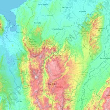
Name: Antioquia topographic map, elevation, terrain.
Location: Antioquia, RAP del Agua y la Montaña, Colombia (5.41863 -77.12709 8.88980 -73.87959)
Average elevation: 608 m
Minimum elevation: -4 m
Maximum elevation: 3,838 m
Other topographic maps
Click on a map to view its topography, its elevation and its terrain.
Bogota
The city is located in the center of Colombia, on a high plateau known as the Bogotá savanna, part of the Altiplano Cundiboyacense located in the Eastern Cordillera of the Andes. Its altitude averages 2,640 meters (8,660 ft) above sea level. Subdivided into 20 localities, Bogotá has an area of 1,587 square…
Average elevation: 2,735 m
Medellín
Colombia > Antioquia > Medellín
Medellín has 16 comunas (districts), 5 corregimientos (townships), and 271 barrios (neighborhoods). The metropolitan area of Medellín lies within the Aburrá valley at an elevation of 1,500 metres (4,900 feet) above sea level and is bisected by the Medellín River (also called Porce), which flows northward.…
Average elevation: 2,098 m
Manizales
Manizales is the capital city of one of the smallest Colombian departments. The city is described as having an "abrupt topography", and lies on the Colombian Central Mountain Range (part of the longest continental mountain range, the Andes), with a great deal of ridgelines and steep slopes, which, combined…
Average elevation: 2,010 m
Sierra Nevada de Santa Marta
Colombia > Magdalena > Aracataca
The Sierra Nevada de Santa Marta (English: Snow-Covered Mountain Range of Saint Martha) is an isolated mountain range in northern Colombia, separate from the Andes range that runs through the north of the country. Reaching an elevation of 5,700 m (18,700 ft) just 42 km (26 mi) from the Caribbean coast, the…
Average elevation: 5,013 m
San Andrés
Colombia > Archipelago of San Andrés, Providencia and Santa Catalina
It is situated at the north end of San Andrés Island in the Caribbean Sea, and forms part of the Colombian archipelago of San Andrés, Providencia and Santa Catalina. It is located about 710 km (440 mi) northwest of mainland Colombia, and 180 km (110 mi) off the eastern coast of Nicaragua. Spread across an…
Average elevation: 0 m
Andes
Andes is a municipality and town in the Antioquia Department, Colombia. Part of the sub-region of Southwestern Antioquia, it is located on the western Colombian Andes mountain range. Andes was founded on 13 March 1852 by Pedro Antonio Restrepo Escobar. Its elevation is 1,360 metres above sea level with an…
Average elevation: 1,559 m
Pico Cristóbal Colón
Colombia > Magdalena > Santa Marta
Pico Cristóbal Colón is possibly the highest mountain in Colombia, with a reported height of 5,775 metres (18,947 ft). Pico Cristóbal Colón and Pico Simón Bolívar are the two highest peaks in Colombia and almost equal in elevation. One of the two mountains is therefore the fifth most prominent in the…
Average elevation: 5,111 m
Leticia
Leticia (Spanish pronunciation: [leˈtisja]) is the southernmost city in the Republic of Colombia, capital of the department of Amazonas, Colombia's southernmost town (4.09° south 69.57° west) and one of the major ports on the Amazon River. It has an elevation of 96 meters (315') above sea level and an…
Average elevation: 71 m
Andes
Andes is a municipality and town in the Antioquia Department, Colombia. Part of the sub-region of Southwestern Antioquia, it is located on the western Colombian Andes mountain range. Andes was founded on 13 March 1852 by Pedro Antonio Restrepo Escobar. Its elevation is 1,360 metres above sea level with an…
Average elevation: 1,559 m
Galeras
Numerous minor tremors and ash emissions since March 2006 culminated on 12 July 2006 in three explosive eruptions, producing an ash and gas column reaching an altitude of 8 kilometres (5.0 mi). Rock falls and pyroclastic flows were reported from towns as distant as Consacá, 11.4 kilometres (7.1 mi) west of…
Average elevation: 3,847 m
Cerro de Monserrate
Colombia > Bogota, Capital District
Both Monserrate and its neighbor Guadalupe Hill are icons of Bogota's cityscape. The hill is a tourist attraction with access by funicular or cable car (both of which charge a fee) or the pilgrimage hiking trail (free). The hiking path is 2.4 km (1.5 mi), where you can walk up the steep hill on a journey that…
Average elevation: 2,884 m
Cúcuta
Colombia > Norte de Santander > Cúcuta > Cúcuta
The city is in the eastern part of the Department of North Santander, in the Cordillera Oriental, close to the border with Venezuela. The city's area is 110 square kilometres (42 square miles) and its elevation is 320 metres (1,050 feet) above sea level.
Average elevation: 575 m
Rionegro
Colombia > Antioquia > Rionegro
The city of Rionegro is located at 6°9′18″N 75°22′48″W / 6.15500°N 75.38000°W / 6.15500; -75.38000, at an average elevation of 2,125 metres (6,972 ft) above sea level. The average annual precipitation varies between 1,800 and 2,500 millimetres (71 and 98 in) with an average temperature of…
Average elevation: 2,232 m
Tunja
Tunja has a population of 172,548 inhabitants according to the 2018 Census. 0.1% of the city is indigenous, 0.4% is black, and 99.5% is white and Mestizo. It is located in central Colombia, at an elevation ranging from approximately 2,700 metres (8,900 ft) to 2,900 metres (9,500 ft). The city centre is at an…
Average elevation: 2,824 m
Cove Road
Colombia > Archipelago of San Andrés, Providencia and Santa Catalina > San Andrés
Average elevation: 12 m
Pico Simón Bolívar
Colombia > Magdalena > Aracataca
Pico Simón Bolívar is possibly the highest mountain in Colombia, with an estimated height of 5,720 metres (18,770 ft). Pico Bolívar and the neighbouring summit of Pico Cristóbal Colón are the two highest peaks in Colombia and are very nearly equal in elevation. The height difference is about 7 meters. For…
Average elevation: 5,174 m
Cordillera Central
The Cauca Valley montane forests ecoregion covers the western slope of the range. The Magdalena Valley montane forests cover the eastern slopes and the northern end of the cordillera. The Northern Andean páramo covers the highest elevations.
Average elevation: 3,706 m
Rionegro
Colombia > Antioquia > Rionegro
The city of Rionegro is located at 6°9′18″N 75°22′48″W / 6.15500°N 75.38000°W / 6.15500; -75.38000, at an average elevation of 2,125 metres (6,972 ft) above sea level. The average annual precipitation varies between 1,800 and 2,500 millimetres (71 and 98 in) with an average temperature of…
Average elevation: 2,232 m
Palomino
Colombia > La Guajira > Dibulla
Palomino is located in the municipality of Dibulla part of the department of Guajira and is only 2 meters above sea level. It is one of the five towns that form the municipality of Dibulla. It is located on the foothills of the Sierra Nevada Mountains of Colombia. The Sierra Nevada de Santa Marta, declared as…
Average elevation: 51 m
Volcán Nevado del Ruiz
The summit of the volcano has steep slopes inclining from 20 to 30 degrees. At lower elevations, the slopes become less steep; their inclination is about 10 degrees. From there on, foothills stretch almost to the edge of the Magdalena River, north of the volcano and the Cauca River to the west. On the two…
Average elevation: 5,119 m
Sierra Nevada de Santa Marta
Colombia > Magdalena > Aracataca
The Sierra Nevada de Santa Marta (English: Snow-Covered Mountain Range of Saint Martha) is an isolated mountain range in northern Colombia, separate from the Andes range that runs through the north of the country. Reaching an elevation of 5,700 m (18,700 ft) just 42 km (26 mi) from the Caribbean coast, the…
Average elevation: 5,013 m
Volcán Nevado del Ruiz
The summit of the volcano has steep slopes inclining from 20 to 30 degrees. At lower elevations, the slopes become less steep; their inclination is about 10 degrees. From there on, foothills stretch almost to the edge of the Magdalena River, north of the volcano and the Cauca River to the west. On the two…
Average elevation: 5,119 m
Eco Parque Macadamia Extremo
Colombia > Cundinamarca > La Mesa > Condominio Altavista
Average elevation: 1,201 m
Sabaneta
Colombia > Antioquia > Sabaneta
Its topography varies from flat reliefs and slight hills to places with steep slopes. Its most notable heights are those of Piedras Blancas (2,650 mamsl) in La Romera, the Cuchilla Santa Teresa (2,200 mamsl), the hill of Los Gallinazos in Pan de Azúcar (1,800 mamsl), the hill Morrón, La Siberia and the Ancón.
Average elevation: 1,787 m
Caucasia
Colombia > Antioquia > Caucasia
The municipality of Caucasia is located at the northern department of Antioquia, on the border with the department of Córdoba and the subregion of Bajo Cauca Antioquia. It lies at an altitude of 150 m (490 ft) above sea level. Its territory is a flat area with small ridges in the north and west and south. It…
Average elevation: 63 m