Geolocate

Barranquilla topographic map

Click on the map to display elevation.

About this map

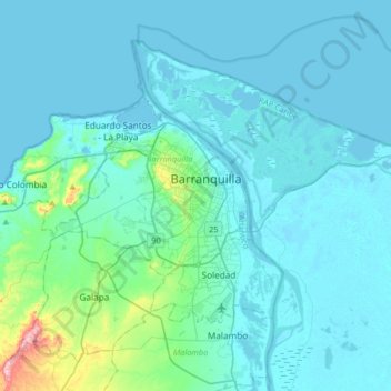
Name: Barranquilla topographic map, elevation, terrain.

Location: Barranquilla, Atlántico, Caribe, 080006, Colombia (10.81997 -74.96131 11.13997 -74.64131)

Average elevation: 27 m

Minimum elevation: -3 m

Maximum elevation: 298 m

Other topographic maps

Click on a map to view its topography, its elevation and its terrain.

El Golfo

Colombia > Atlántico > Barranquilla

Average elevation: 28 m

Gear up for your next adventure:

Camping Tent - Weather-resistant tents suitable for 2 to 6 people
🥾Hiking Boots - Sturdy boots providing ankle support and traction on rugged trails
🥾Hiking Leggings - Comfortable leggings for outdoor activities
🚲MTB Frame Bag - Carry tools and maps directly on your bicycle frame
💡Compact LED Flashlight - Powerful and portable flashlight for outdoor use

As an Amazon Associate, this site earns from qualifying purchases at no extra cost to you.