Make a donation
Gear up for your next adventure:
As an Amazon Associate, this site earns from qualifying purchases at no extra cost to you.
Currie topographic map
Click on the map to display elevation.
Make a donation
Gear up for your next adventure:
As an Amazon Associate, this site earns from qualifying purchases at no extra cost to you.
Currie
The period 1921-1951 brought great changes with the building of more council houses in Currie and private building along Lanark Road. Wider scale development began in the late 1950s and early 1960s with the construction of a private housing estate to the east of Curriehill Road. House builders began to promote Currie as a pleasant commuting suburb of Edinburgh and much house building took place to the north of Lanark Road West. Currie High School was constructed on its present site in 1966 and extensively refurbished and renewed in 1997. There was a Currie station on a short loop railway running over what is now the Water of Leith Walkway. The physical topography has ensured that the original historic core to the south of Lanark Road West including the Water of Leith has remained undeveloped. In March 1972 the historic centre of Currie was declared a Conservation Area.
Make a donation
Gear up for your next adventure:
As an Amazon Associate, this site earns from qualifying purchases at no extra cost to you.
About this map
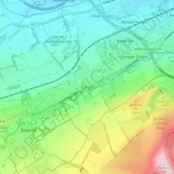
Name: Currie topographic map, elevation, terrain.
Location: Currie, City of Edinburgh, Scotland, United Kingdom (55.87122 -3.34942 55.92152 -3.26916)
Average elevation: 163 m
Minimum elevation: 60 m
Maximum elevation: 419 m
Make a donation
Gear up for your next adventure:
As an Amazon Associate, this site earns from qualifying purchases at no extra cost to you.
Other topographic maps
Click on a map to view its topography, its elevation and its terrain.
Make a donation
Gear up for your next adventure:
As an Amazon Associate, this site earns from qualifying purchases at no extra cost to you.
Make a donation
Gear up for your next adventure:
As an Amazon Associate, this site earns from qualifying purchases at no extra cost to you.
Make a donation
Gear up for your next adventure:
As an Amazon Associate, this site earns from qualifying purchases at no extra cost to you.
Make a donation
Gear up for your next adventure:
As an Amazon Associate, this site earns from qualifying purchases at no extra cost to you.
Make a donation
Gear up for your next adventure:
As an Amazon Associate, this site earns from qualifying purchases at no extra cost to you.
Make a donation
Gear up for your next adventure:
As an Amazon Associate, this site earns from qualifying purchases at no extra cost to you.
Make a donation
Gear up for your next adventure:
As an Amazon Associate, this site earns from qualifying purchases at no extra cost to you.
St Mark's Park Community Woodland
United Kingdom > Scotland > City of Edinburgh
Average elevation: 23 m
