Geolocate

Scottish Borders topographic map

Click on the map to display elevation.

About this map

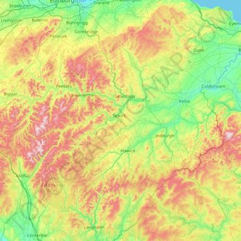
Name: Scottish Borders topographic map, elevation, terrain.

Location: Scottish Borders, Scotland, United Kingdom (55.10834 -3.53980 55.94662 -2.03321)

Average elevation: 257 m

Minimum elevation: 0 m

Maximum elevation: 836 m

Other topographic maps

Click on a map to view its topography, its elevation and its terrain.

Edinburgh

United Kingdom > Scotland > Edinburgh

Some have called Edinburgh the Athens of the North for a variety of reasons. The earliest comparison between the two cities showed that they had a similar topography, with the Castle Rock of Edinburgh performing a similar role to the Athenian Acropolis. Both of them had flatter, fertile agricultural land…

Average elevation: 104 m

Glasgow

United Kingdom > Scotland > Glasgow City

Glasgow itself was reputed to have been founded by the Christian missionary Saint Mungo in the 6th century. He established a church on the Molendinar Burn, where the present Glasgow Cathedral stands, and in the following years Glasgow became a religious centre. Glasgow grew over the following centuries. The…

Average elevation: 128 m

Scottish Highlands

United Kingdom > Scotland > Highland

The Scottish Highlands are renowned for their rugged, mountainous terrain that dominates much of the region. Stretching across the northern and central parts of Scotland, the landscape is shaped by ancient geological forces, including the Caledonian Orogeny, which caused significant tectonic collisions…

Average elevation: 907 m

Peebles

United Kingdom > Scotland > Scottish Borders

Average elevation: 275 m

Dunfermline

United Kingdom > Scotland > Fife > Dunfermline

Average elevation: 80 m

Ben Nevis

United Kingdom > Scotland > Highland

Ben Nevis has a highland (alpine) maritime (oceanic) polar climate (ET climate in the Köppen classification). Ben Nevis's elevation, maritime location and topography frequently lead to cool and cloudy weather conditions, which can pose a danger to ill-equipped walkers. According to the observations carried…

Average elevation: 912 m

River Devon

United Kingdom > Scotland > Clackmannanshire > Tillicoultry

The source of the river is Blairdenon Hill in the Ochils at an altitude of 1,800 feet (550 m). Upper areas have been dammed, creating Upper Glendevon, Lower Glendevon and Castlehill reservoirs. The Devon then flows east and southeast through Glendevon, turning southwest at Crook of Devon and then continuing…

Average elevation: 96 m

Glasgow

United Kingdom > Scotland > Glasgow City

Glasgow itself was reputed to have been founded by the Christian missionary Saint Mungo in the 6th century. He established a church on the Molendinar Burn, where the present Glasgow Cathedral stands, and in the following years Glasgow became a religious centre. Glasgow grew over the following centuries as part…

Average elevation: 128 m

Scottish Highlands

United Kingdom > Scotland > Highland

The entire region was covered by ice sheets during the Pleistocene ice ages, save perhaps for a few nunataks. The complex geomorphology includes incised valleys and lochs carved by the action of mountain streams and ice, and a topography of irregularly distributed mountains whose summits have similar heights…

Average elevation: 907 m

Aberlour

United Kingdom > Scotland > Moray

According to the 1846 A Topographical Dictionary of Scotland, "This parish, formerly called Skirdustan, signifying, in the Gaelic tongue, 'the division of Dustan', its tutelary saint, derived its present name from its situation at the mouth of a noisy burn, which discharges itself into the river Spey."

Average elevation: 160 m

Kirkcaldy

United Kingdom > Scotland > Fife

Towards the end of the 16th century, a detailed assessment on the size of the townscape was carried out. The first estimate of the parish population in 1639 was between 3,000 and 3,200 and around 3,400 by 1691. At the beginning of the 18th century, the population declined. A census by Webster's Topographical…

Average elevation: 50 m

Livingston

United Kingdom > Scotland > West Lothian

Average elevation: 158 m

Hawick

United Kingdom > Scotland > Scottish Borders

Average elevation: 199 m

Aviemore

United Kingdom > Scotland > Highland

Average elevation: 331 m

Comrie

United Kingdom > Scotland > Perth and Kinross

Average elevation: 111 m

Bellshill

United Kingdom > Scotland > North Lanarkshire

Average elevation: 73 m

Banffshire

United Kingdom > Scotland

Average elevation: 191 m

Arisaig

United Kingdom > Scotland > Highland

Average elevation: 54 m

Heriot

United Kingdom > Scotland > Scottish Borders

Average elevation: 323 m

Auldearn

United Kingdom > Scotland > Highland

Average elevation: 37 m

Brora

United Kingdom > Scotland > Highland

Average elevation: 14 m

Comrie

United Kingdom > Scotland > Fife

Average elevation: 83 m

Kirkwall

United Kingdom > Scotland > Orkney Islands

Average elevation: 27 m

Càrn Mòr Dearg

United Kingdom > Scotland > Highland

Average elevation: 892 m

Scone

United Kingdom > Scotland > Perth and Kinross

Average elevation: 81 m

Cullochy Lock

United Kingdom > Scotland > Highland

Average elevation: 143 m

Stornoway

United Kingdom > Scotland > Western Isles

Average elevation: 34 m

Argyll and Bute

United Kingdom > Scotland

Average elevation: 683 m

The Campsie Fells

United Kingdom > Scotland

Average elevation: 431 m

Western Isles

United Kingdom > Scotland

Average elevation: 23 m

Ayrshire

United Kingdom > Scotland

Average elevation: 141 m

Inchmickery

United Kingdom > Scotland

Average elevation: 0 m

Ailsa Craig

United Kingdom > Scotland

In a small glen above Ailsa Castle, a small freshwater body known as the Garry Loch is located at an altitude of 247 m (810 ft), with a depth of at least 17 feet.

Average elevation: 14 m

Iona

United Kingdom > Scotland

Average elevation: 9 m

Torridon

United Kingdom > Scotland > Highland

Average elevation: 236 m

Stirlingshire

United Kingdom > Scotland

Average elevation: 222 m

Mull of Kintyre

United Kingdom > Scotland

Ailsa Craig and the County Antrim coast of Ulster and Rathlin Island are all clearly visible from the Mull. On clearer days it is also possible to make out Malin Head in Inishowen in County Donegal in the west of Ulster, and the Ayrshire coast on the other side of Ailsa Craig. Other islands in the Firth of…

Average elevation: 84 m

Glen Dochart

United Kingdom > Scotland

Average elevation: 469 m

Auchencorth Moss

United Kingdom > Scotland

Average elevation: 281 m

Denton Burn

United Kingdom > Scotland

Average elevation: 154 m

Taynish Island

United Kingdom > Scotland

Average elevation: 11 m

Devil's Beef Tub

United Kingdom > Scotland

Average elevation: 376 m

Grey Mare's Tail

United Kingdom > Scotland

Average elevation: 466 m

Meall Aundrary

United Kingdom > Scotland

Average elevation: 194 m

River Kerry

United Kingdom > Scotland

Average elevation: 118 m

Burian Hole

United Kingdom > Scotland

Average elevation: 36 m

Papa

United Kingdom > Scotland

Average elevation: 2 m

Sgùrr na Stri

United Kingdom > Scotland

Average elevation: 92 m

Braid Hill

United Kingdom > Scotland

Average elevation: 353 m

Loch Urigill

United Kingdom > Scotland

Average elevation: 172 m

Buachaille Etive Mor

United Kingdom > Scotland

Average elevation: 585 m

Highland

United Kingdom > Scotland

Average elevation: 402 m

Glen Croe

United Kingdom > Scotland

Average elevation: 355 m

Inverness-shire

United Kingdom > Scotland

Average elevation: 333 m

Barrnacarry Bay

United Kingdom > Scotland

Average elevation: 32 m

Laurencekirk

United Kingdom > Scotland > Aberdeenshire

Average elevation: 105 m

Cromarty

United Kingdom > Scotland > Highland

Average elevation: 35 m

Snap

United Kingdom > Scotland

Average elevation: 3 m

Lanarkshire

United Kingdom > Scotland

Average elevation: 183 m

Rubha nam Bùthan

United Kingdom > Scotland

Average elevation: 15 m

The Minch

United Kingdom > Scotland

Average elevation: 63 m

Firth of Clyde

United Kingdom > Scotland

Average elevation: 0 m

St Magnus' Bay

United Kingdom > Scotland

Average elevation: 6 m

Aberdeen

United Kingdom > Scotland > Aberdeen

Two weather stations collect climate data for the area, Aberdeen/Dyce Airport, and Craibstone. Both are about 4 1⁄2 miles (7 km) to the north west of the city centre, and given that they are in close proximity to each other, exhibit very similar climatic regimes. Dyce tends to have marginally warmer daytime…

Average elevation: 52 m

Dundee

United Kingdom > Scotland > Dundee City

Dundee sits on the north bank of the Firth of Tay on the eastern, North Sea Coast of Scotland. The city lies 36.1 miles (58 km) NNE of Edinburgh and 360.6 miles (580 km) NNW of London. The built-up area occupies a roughly rectangular shape 8.3 miles (13 km) long by 2.5 miles (4 km) wide, aligned in an east to…

Average elevation: 82 m

Stirling

United Kingdom > Scotland > Stirling

Average elevation: 161 m

Inverness

United Kingdom > Scotland > Highland

Average elevation: 163 m

Moffat

United Kingdom > Scotland > Dumfries and Galloway

Average elevation: 225 m

Dalkeith

United Kingdom > Scotland > Midlothian

Average elevation: 95 m

Dufftown

United Kingdom > Scotland > Moray

Average elevation: 268 m

Bathgate

United Kingdom > Scotland > West Lothian

In the 1846 book A Topographical Dictionary of Scotland, Samuel Lewis writes.

Average elevation: 167 m

Aberfeldy

United Kingdom > Scotland > Perth and Kinross

Average elevation: 304 m

Thurso

United Kingdom > Scotland > Highland

Average elevation: 25 m

Cumbernauld

United Kingdom > Scotland > North Lanarkshire > Cumbernauld

Cumbernauld's name probably comes from the Gaelic comar nan allt, meaning "meeting of the burns or streams". There are differing views as to the etymology of this. One theory is that from its high point in the Central Belt, its streams flow both west to the River Clyde and east to the Firth of Forth so…

Average elevation: 111 m

Largs

United Kingdom > Scotland > North Ayrshire

Average elevation: 110 m

New Cumnock

United Kingdom > Scotland > East Ayrshire

Average elevation: 275 m

Coulter

United Kingdom > Scotland > South Lanarkshire

Average elevation: 253 m

Grampian Mountains

United Kingdom > Scotland > Highland

Average elevation: 775 m

Balerno

United Kingdom > Scotland > Balerno

Average elevation: 194 m

Lochcraig

United Kingdom > Scotland > Fife > Glencraig

Average elevation: 116 m

Ford

United Kingdom > Scotland > Argyll and Bute

Average elevation: 125 m

Coylton

United Kingdom > Scotland > South Ayrshire

Average elevation: 77 m

Kyle of Lochalsh

United Kingdom > Scotland > Highland

Average elevation: 39 m

Awe Barrage

United Kingdom > Scotland > Argyll and Bute

Average elevation: 263 m

East Calder

United Kingdom > Scotland > West Lothian

Average elevation: 140 m

Wigtown

United Kingdom > Scotland > Dumfries and Galloway

Wigtown Castle was in existence by 1291, on flat land down by the River Bladnoch, (outlines clearly seen on an aerial view), whilst the town and church were on a hill, "an inversion of the usual arrangements". Nothing remains of the castle, although a strong natural site and indication of a large enclosed and…

Average elevation: 18 m

Falkirk

United Kingdom > Scotland > Falkirk

Falkirk is located in an area of undulating topography between the Slamannan Plateau and the upper reaches of the Firth of Forth. The area to the north of Falkirk is part of the floodplain of the River Carron. Two tributaries of the River Carron - the East Burn and the West Burn flow through the town and form…

Average elevation: 69 m

Jedburgh

United Kingdom > Scotland > Scottish Borders

Average elevation: 151 m

Gear up for your next adventure:

🧴First Aid Kit - Essential first aid supplies for outdoor emergencies
🧭GPS Handheld Device - Reliable GPS navigation for outdoor adventures
🧴Bear Spray Holster - Quick-access carry for essential Canadian wilderness safety
🎒Backpack Rain Cover - External shield to keep your entire pack dry
💡Solar Camping Lamp - Eco-friendly lighting for campsites

As an Amazon Associate, this site earns from qualifying purchases at no extra cost to you.