
Umbria topographic map
Interactive map
Click on the map to display elevation.
About this map
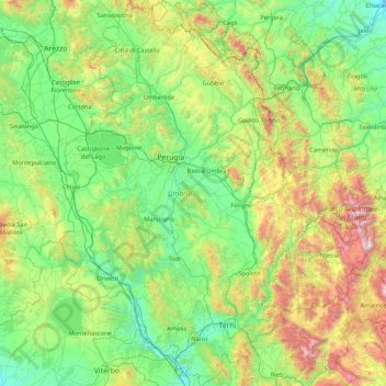
Name: Umbria topographic map, elevation, terrain.
Location: Umbria, Italy (42.36478 11.89203 43.61734 13.26419)
Average elevation: 521 m
Minimum elevation: 15 m
Maximum elevation: 2,445 m
Umbria is bordered by Tuscany to the west and the north, Marche to the east and Lazio to the south. Partly hilly and mountainous, and partly flat and fertile owing to the valley of the Tiber, its topography includes part of the central Apennines, with the highest point in the region at Monte Vettore on the border of the Marche, at 2,476 metres (8,123 feet); the lowest point is Attigliano, 96 metres (315 feet). It is the only Italian region having neither a coastline nor a common border with other countries. The comune of Città di Castello has an exclave named Monte Ruperto within Marche. Contained within Umbria is the hamlet of Cospaia, which was a tiny republic from 1440 to 1826, created by accident.
Other topographic maps
Click on a map to view its topography, its elevation and its terrain.
Campo Imperatore
Italy > Abruzzo > L'Aquila > L'Aquila
Campo Imperatore, L'Aquila, Abruzzo, 67026, Italy
Average elevation: 2,056 m
View on hills and ‘drunk’ roads
Italy > Tuscany > Siena > Pienza
View on hills and ‘drunk’ roads, Strada Comunale Pienza-Monticchiello, Podere Fonte all'Oppio, Pienza, Unione dei Comuni Valdichiana Senese, Siena, Tuscany, 53026, Italy
Average elevation: 388 m
Campo Soriano
Italy > Lazio > Latina > Terracina
Campo Soriano, Terracina, Latina, Lazio, Italy
Average elevation: 437 m
Pics
Italy > Friuli-Venezia Giulia > Udine > Montenars
Pics, Montenars, Udine, Friuli-Venezia Giulia, 33010, Italy
Average elevation: 798 m
Piazza al Serchio
Piazza al Serchio, Unione Comuni Garfagnana, Lucca, Tuscany, 55035, Italy
Average elevation: 831 m
Stilfs - Stelvio
Italy > Trentino-Alto Adige/Südtirol > South Tyrol
Stilfs - Stelvio, Vinschgau - Val Venosta, South Tyrol, Trentino-Alto Adige/Südtirol, 39029, Italy
Average elevation: 2,419 m
Villa Borghese Park
Italy > Lazio > Roma Capitale > Rome
Villa Borghese Park, Rome, Roma Capitale, Lazio, Italy
Average elevation: 52 m
Grassi
Italy > Emilia-Romagna > Piacenza > Bettola
Grassi, Bettola, Piacenza, Emilia-Romagna, Italy
Average elevation: 708 m
Lauco
Italy > Friuli-Venezia Giulia > Udine
Lauco, Udine, Friuli-Venezia Giulia, 33029, Italy
Average elevation: 1,014 m
Rocca San Casciano
Rocca San Casciano, Unione di Comuni della Romagna Forlivese, Forlì-Cesena, Emilia-Romagna, 47017, Italy
Average elevation: 423 m
Monte Cassino
Italy > Lazio > Frosinone > Cassino
Monte Cassino, Cassino, Frosinone, Lazio, 03043, Italy
Average elevation: 231 m
Castel Gandolfo
Italy > Lazio > Roma Capitale
Castel Gandolfo, Roma Capitale, Lazio, 00073, Italy
Average elevation: 306 m
Ospitale
Italy > Emilia-Romagna > Modena
Ospitale, Fanano, Unione dei comuni del Frignano, Modena, Emilia-Romagna, 41021, Italy
Average elevation: 1,186 m
Montecastello
Italy > Piedmont > Alessandria
Montecastello, Alessandria, Piedmont, Italy
Average elevation: 134 m
Polese
Italy > Veneto > Province of Padua > Selvazzano Dentro > Pralungo
Polese, Pralungo, Selvazzano Dentro, Province of Padua, Veneto, 35030, Italy
Average elevation: 16 m
Rovereto
Italy > Trentino-Alto Adige/Südtirol > Provincia di Trento
Rovereto, Comunità della Vallagarina, Provincia di Trento, Trentino-Alto Adige/Südtirol, 38068, Italy
Average elevation: 709 m
Cascina Confaloniera
Italy > Lombardy > Milan > Rosate
Cascina Confaloniera, Rosate, Unione dei Comuni I Fontanili, Milan, Lombardy, 20088, Italy
Average elevation: 107 m
Etsch - Adige
Italy > Trentino-Alto Adige/Südtirol > South Tyrol > Tarnell - Tarnello > Oberplatz
Etsch - Adige, Oberplatz, Tarnell - Tarnello, Laas - Lasa, Vinschgau - Val Venosta, South Tyrol, Trentino-Alto Adige/Südtirol, 39023, Italy
Average elevation: 1,075 m
Villotta
Italy > Friuli-Venezia Giulia > Pordenone
Villotta, Chions, Pordenone, Friuli-Venezia Giulia, 33083, Italy
Average elevation: 14 m
Eisacktal - Valle Isarco
Italy > Trentino-Alto Adige/Südtirol > South Tyrol
Eisacktal - Valle Isarco, South Tyrol, Trentino-Alto Adige/Südtirol, Italy
Average elevation: 1,487 m