
Castel Gandolfo topographic map
Click on the map to display elevation.
Castel Gandolfo
The maximum elevation registered in the territory is 425 m (1,390 ft) above sea level, at the Collegio di Propaganda Fide adjoining Villa Barberini. On the crown of the hills around the Lake Albano, the elevation is only 400 m (1,300 ft) above sea level, at the summit of Monte Cucco, bordering Marino.
About this map
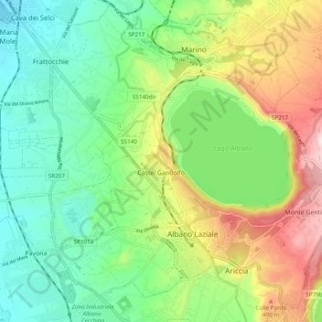
Name: Castel Gandolfo topographic map, elevation, terrain.
Location: Castel Gandolfo, Roma Capitale, Lazio, 00073, Italy (41.72476 12.59258 41.76520 12.68832)
Average elevation: 306 m
Minimum elevation: 131 m
Maximum elevation: 633 m
Other topographic maps
Click on a map to view its topography, its elevation and its terrain.