
Make a donation
Gear up for your next adventure:
As an Amazon Associate, this site earns from qualifying purchases at no extra cost to you.
Tello topographic map
Click on the map to display elevation.
Make a donation
Gear up for your next adventure:
As an Amazon Associate, this site earns from qualifying purchases at no extra cost to you.
Tello
Tello es un municipio colombiano ubicado al norte del departamento del Huila. Su clima es cálido con una temperatura media de 26 ºC; y con una altitud de 575 msnm. Su superficie total es de 557,19 km² y se encuentra a 22 km de la ciudad de Neiva.
Make a donation
Gear up for your next adventure:
As an Amazon Associate, this site earns from qualifying purchases at no extra cost to you.
About this map
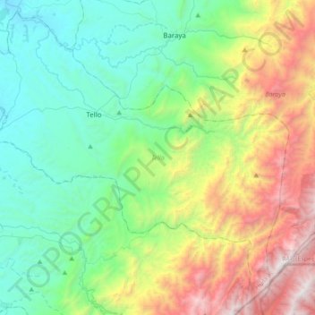
Name: Tello topographic map, elevation, terrain.
Location: Tello, Norte, Huila, RAP (Especial) Central, Colombia (2.86385 -75.27217 3.17806 -74.93034)
Average elevation: 865 m
Minimum elevation: 378 m
Maximum elevation: 3,166 m
Make a donation
Gear up for your next adventure:
As an Amazon Associate, this site earns from qualifying purchases at no extra cost to you.
Other topographic maps
Click on a map to view its topography, its elevation and its terrain.
Campoalegre
Estas manzanas aprovecharon la topografía relativamente plana y con leve pendiente este a oeste, limitada al sur por la quebrada La Caraguaja, y al norte por el Río Frío, dividido por el arroyo del Lavapatas. El núcleo se constituyó en el elemento generador de las principales actividades humanas, con sus…
Average elevation: 540 m
Make a donation
Gear up for your next adventure:
As an Amazon Associate, this site earns from qualifying purchases at no extra cost to you.
Make a donation
Gear up for your next adventure:
As an Amazon Associate, this site earns from qualifying purchases at no extra cost to you.
Make a donation
Gear up for your next adventure:
As an Amazon Associate, this site earns from qualifying purchases at no extra cost to you.
Make a donation
Gear up for your next adventure:
As an Amazon Associate, this site earns from qualifying purchases at no extra cost to you.
Make a donation
Gear up for your next adventure:
As an Amazon Associate, this site earns from qualifying purchases at no extra cost to you.
Make a donation
Gear up for your next adventure:
As an Amazon Associate, this site earns from qualifying purchases at no extra cost to you.
Make a donation
Gear up for your next adventure:
As an Amazon Associate, this site earns from qualifying purchases at no extra cost to you.
Make a donation
Gear up for your next adventure:
As an Amazon Associate, this site earns from qualifying purchases at no extra cost to you.
Make a donation
Gear up for your next adventure:
As an Amazon Associate, this site earns from qualifying purchases at no extra cost to you.
Aipe
Colombia > Huila > Aipe > Aipe
Aipe es un municipio colombiano ubicado en el noroccidente del departamento de Huila. Tiene una extensión territorial de 801.04 km², que corresponde al 3.8% del área total del departamento. Está ubicado a una altitud de 350 metros sobre el nivel de mar, con temperatura promedio anual de 28.4°C. El casco…
Average elevation: 398 m
Make a donation
Gear up for your next adventure:
As an Amazon Associate, this site earns from qualifying purchases at no extra cost to you.
Algeciras
Algeciras es una ciudad y municipio español de la provincia de Cádiz, en la comunidad autónoma de Andalucía. Es la mayor ciudad del Campo de Gibraltar y la sede de la mancomunidad de municipios de dicha comarca, junto con los cuales forma su área metropolitana. Está situada en la bahía de Algeciras,…
Average elevation: 1,051 m
Tello
Colombia > Huila > Tello > Tello
Tello es un municipio colombiano ubicado en el departamento de Huila. Se caracteriza por su extensa llanura comprendida entre el río Magdalena y el pie de la cordillera oriental hasta sus cimas, con más de 3000 msnm, regados por las aguas de los ríos Fortalecillas y Villavieja. Su extensión territorial es…
Average elevation: 604 m
Make a donation
Gear up for your next adventure:
As an Amazon Associate, this site earns from qualifying purchases at no extra cost to you.
Make a donation
Gear up for your next adventure:
As an Amazon Associate, this site earns from qualifying purchases at no extra cost to you.
Make a donation
Gear up for your next adventure:
As an Amazon Associate, this site earns from qualifying purchases at no extra cost to you.
Make a donation
Gear up for your next adventure:
As an Amazon Associate, this site earns from qualifying purchases at no extra cost to you.
Make a donation
Gear up for your next adventure:
As an Amazon Associate, this site earns from qualifying purchases at no extra cost to you.
Make a donation
Gear up for your next adventure:
As an Amazon Associate, this site earns from qualifying purchases at no extra cost to you.
Make a donation
Gear up for your next adventure:
As an Amazon Associate, this site earns from qualifying purchases at no extra cost to you.
Make a donation
Gear up for your next adventure:
As an Amazon Associate, this site earns from qualifying purchases at no extra cost to you.
Make a donation
Gear up for your next adventure:
As an Amazon Associate, this site earns from qualifying purchases at no extra cost to you.
Make a donation
Gear up for your next adventure:
As an Amazon Associate, this site earns from qualifying purchases at no extra cost to you.
Make a donation
Gear up for your next adventure:
As an Amazon Associate, this site earns from qualifying purchases at no extra cost to you.
Make a donation
Gear up for your next adventure:
As an Amazon Associate, this site earns from qualifying purchases at no extra cost to you.
Make a donation
Gear up for your next adventure:
As an Amazon Associate, this site earns from qualifying purchases at no extra cost to you.
Make a donation
Gear up for your next adventure:
As an Amazon Associate, this site earns from qualifying purchases at no extra cost to you.
Make a donation
Gear up for your next adventure:
As an Amazon Associate, this site earns from qualifying purchases at no extra cost to you.