
Salen topographic map
Click on the map to display elevation.
About this map
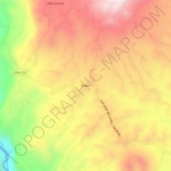
Name: Salen topographic map, elevation, terrain.
Location: Salen, Isnos, Sur, Huila, RAP (Especial) Central, Colombia (1.92170 -76.28026 1.96170 -76.24026)
Average elevation: 1,811 m
Minimum elevation: 1,392 m
Maximum elevation: 2,104 m
Other topographic maps
Click on a map to view its topography, its elevation and its terrain.
Parque Nacional Natural Puracé
El parque nacional natural Puracé se encuentra en la reserva de biosfera del cinturón andino, región del Macizo Colombiano perteneciente a la cordillera Central de los Andes en Colombia. Su superficie hace parte de los departamentos del Cauca y del Huila. Su altitud es de 4646 msnm; en el parque se…
Average elevation: 2,708 m