
Vegalarga topographic map
Click on the map to display elevation.
About this map
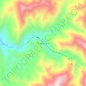
Name: Vegalarga topographic map, elevation, terrain.
Average elevation: 1,363 m
Minimum elevation: 1,043 m
Maximum elevation: 1,734 m
Other topographic maps
Click on a map to view its topography, its elevation and its terrain.
Perímetro Urbano Neiva
Debido a su ubicación cerca de la línea del ecuador y su baja altitud, la ciudad tiene se encuentra en el piso térmico cálido con temperaturas anuales promedio durante el día que van desde 21 hasta 35 grado celsius. La variable temperatura siempre guarda cierta relación con la precipitación, de manera…
Average elevation: 469 m