Geolocate

Villavieja topographic map

Click on the map to display elevation.

About this map

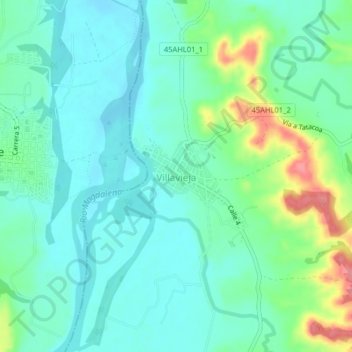
Name: Villavieja topographic map, elevation, terrain.

Location: Villavieja, Norte, Huila, Colombia (3.19954 -75.23903 3.23954 -75.19903)

Average elevation: 391 m

Minimum elevation: 368 m

Maximum elevation: 455 m

Gear up for your next adventure:

🥾Lightweight Hiking Shoes - Comfortable shoes for day hikes
Lightweight Backpacking Tent - Compact tent for efficient hiking trips
🧢Sun Hat - Wide-brim hat for sun protection
Lightweight Camping Tent - Portable shelter optimized for Canadian backcountry camping
🪑Insulated Seat Pad - Protect your seat from cold rocks and wet logs

As an Amazon Associate, this site earns from qualifying purchases at no extra cost to you.