
County Carlow topographic map
Interactive map
Click on the map to display elevation.
About this map
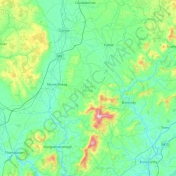
Name: County Carlow topographic map, elevation, terrain.
Location: County Carlow, Leinster, Ireland (52.46359 -7.10794 52.91802 -6.50494)
Average elevation: 126 m
Minimum elevation: 0 m
Maximum elevation: 789 m
The soils of the county are mostly derived from glacial till, rather than solid bedrock geology. These typically consist of a mix of clay, sand and gravel. Occasionally glacial melt-water would form a long ridge of sand and gravel known as an esker. One such example is preserved within the county and is a proposed natural heritage area, referred to as the Ballymoon Esker. The north of the county is generally flat, while central and southern Carlow are characterised by an undulating to rolling topography which becomes progressively hillier towards the south and east. The Blackstairs Mountains are the highest and most extensive upland area, with Mount Leinster rising to 794 m (2,605 ft), making it the highest point in both Carlow and Wexford and the seventh highest county top in Ireland.
Other topographic maps
Click on a map to view its topography, its elevation and its terrain.
Cleggan
Cleggan, Conamara Municipal District, County Galway, Connacht, H71 HY36, Ireland
Average elevation: 29 m
Saint Catherines
Saint Catherines, Boherglass ED, Killaloe Municipal District, County Clare, Munster, Ireland
Average elevation: 91 m
Roundwood
Roundwood, The Municipal District of Wicklow, County Wicklow, Leinster, Ireland
Average elevation: 242 m
Newfarm
Newfarm, The Rower, The Municipal District of Callan — Thomastown, County Kilkenny, Leinster, Ireland
Average elevation: 33 m
Millstreet
Millstreet, Municipal District of Macroom, County Cork, Munster, Ireland
Average elevation: 140 m
Road
Road, Ballyburly ED, The Municipal District of Edenderry, County Offaly, Leinster, Ireland
Average elevation: 87 m
Wexford
Wexford, The Borough District of Wexford, County Wexford, Leinster, Ireland
Average elevation: 23 m
The Municipal District of Piltown
The Municipal District of Piltown, County Kilkenny, Leinster, Ireland
Average elevation: 89 m
Dún Laoghaire-Rathdown
Dún Laoghaire-Rathdown, County Dublin, Leinster, Ireland
Average elevation: 139 m
Rathmichael (Bray) ED
Rathmichael (Bray) ED, The Municipal District of Bray, County Wicklow, Leinster, Ireland
Average elevation: 36 m
Listowel
Listowel, Listowel Municipal District, County Kerry, Munster, V31 YK58, Ireland
Average elevation: 43 m
The Municipal District of Callan — Thomastown
The Municipal District of Callan — Thomastown, County Kilkenny, Leinster, Ireland
Average elevation: 100 m
Elphin
Elphin, Elphin ED, Boyle Municipal District, County Roscommon, Connacht, Ireland
Average elevation: 76 m
Market
Ireland > County Limerick > Limerick
Market, The Metropolitan District of Limerick City, Limerick, County Limerick, Munster, Ireland
Average elevation: 12 m
Whitechurch
Whitechurch, Municipal District of Cobh, County Cork, Munster, Ireland
Average elevation: 110 m
Waterfall
Waterfall, Inishkenny, Municipal District of Carrigaline, County Cork, Munster, T12 CYF2, Ireland
Average elevation: 96 m
Bailieborough
Bailieborough, Bailieborough ED, Bailieborough-Cootehill Municipal District, County Cavan, Ulster, A82 NX86, Ireland
Average elevation: 162 m
Cloyne
Cloyne, Cloyne ED, The Municipal District of East Cork, County Cork, Munster, P25 P792, Ireland
Average elevation: 40 m
Killeagh
Killeagh, The Municipal District of East Cork, County Cork, Munster, P36 KN61, Ireland
Average elevation: 64 m
Aughrim
Aughrim, The Municipal District of Arklow, County Wicklow, Leinster, Y14 HT72, Ireland
Average elevation: 123 m
Gortnahoe
Gortnahoe, The Municipal District of Thurles, County Tipperary, Munster, Ireland
Average elevation: 135 m
The Municipal District of Newcastle West
The Municipal District of Newcastle West, County Limerick, Munster, Ireland
Average elevation: 117 m
North West Slob
North West Slob, Ardcavan ED, The Borough District of Wexford, County Wexford, Leinster, Ireland
Average elevation: 1 m
Castledown
Castledown, Heathstown ED, The Municipal District of Mullingar — Kinnegad, County Westmeath, Leinster, Ireland
Average elevation: 97 m
Cliffs of Moher
Cliffs of Moher, Ballysteen ED, West Clare Municipal District, County Clare, Munster, Ireland
Average elevation: 55 m
Hollyfort
Hollyfort, The Municipal District of Gorey — Kilmuckridge, County Wexford, Leinster, Ireland
Average elevation: 145 m
Lough Loung
Lough Loung, Ballynakill ED, Ballinasloe Municipal District, County Galway, Connacht, Ireland
Average elevation: 65 m
Athlone
Athlone, County Westmeath, Leinster, Ireland
Average elevation: 43 m
Monbay Lower
Monbay Lower, Rossminoge ED, The Municipal District of Gorey — Kilmuckridge, County Wexford, Leinster, Ireland
Average elevation: 136 m
Ballymahon Municipal District
Ballymahon Municipal District, County Longford, Leinster, Ireland
Average elevation: 63 m
Mountain River
Mountain River, The Municipal District of Muinebeag, County Carlow, Leinster, Ireland
Average elevation: 136 m
The Municipal District of Gorey — Kilmuckridge
The Municipal District of Gorey — Kilmuckridge, County Wexford, Leinster, Ireland
Average elevation: 58 m
Kilquane
Ireland > County Cork > Municipal District of Cobh
Kilquane, Knockraha, Municipal District of Cobh, County Cork, Munster, Ireland
Average elevation: 131 m
Red Island
Ireland > County Cavan > Carrickclevan
Red Island, Carrickclevan, Drumcarban ED, Ballyjamesduff Municipal District, County Cavan, Ulster, Ireland
Average elevation: 76 m
Great Blasket Island
Great Blasket Island, Toghroinn ceantair Dún Chaoin, Kenmare Municipal District, County Kerry, Munster, Ireland
Average elevation: 21 m
Aughrim
Aughrim, Ballinasloe Municipal District, County Galway, Connacht, Ireland
Average elevation: 68 m
Mount Eagle
Mount Eagle, Westport-Belmullet Municipal District, County Mayo, Connacht, Ireland
Average elevation: 274 m