Geolocate

County Donegal topographic map

Click on the map to display elevation.

County Donegal

The majority of Donegal has a temperate oceanic climate (Köppen climate classification: Cfb), with upland areas in the Derryveagh and Blue Stack ranges classified as oceanic subpolar (Köppen climate classification: Cfc). The county's climate is heavily influenced by the North Atlantic Current. Due to the topography of western Donegal, it receives orographic rainfall, where the air is forced to rise on contact with its mountainous coastline and subsequently cools and condenses, forming clouds. The mountains of Donegal are among the cloudiest places in Ireland, and northern Donegal is the windiest. Irish monthly record wind speeds for March, June, July, September, November and December have all been set at Malin Head. The highest wind speed ever recorded in Donegal was 181 km/h (112 mph) on 16 September 1961, during Hurricane Debbie.

Wikipedia (CC-BY-SA 3.0)

About this map

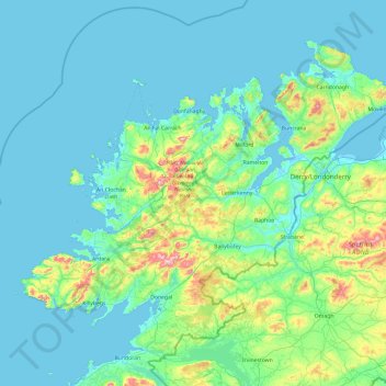
Name: County Donegal topographic map, elevation, terrain.

Location: County Donegal, Ulster, Ireland (54.45905 -8.83471 55.43530 -6.92273)

Average elevation: 74 m

Minimum elevation: -4 m

Maximum elevation: 697 m

Other topographic maps

Click on a map to view its topography, its elevation and its terrain.

Bunbrosna

Ireland > County Westmeath

Average elevation: 97 m

Ballinafad

Ireland > County Sligo

Average elevation: 115 m

Cleggan

Ireland > County Galway

Average elevation: 29 m

Dundrum

Ireland > County Dublin

Average elevation: 79 m

Saint Catherines

Ireland > County Clare

Average elevation: 91 m

Waterfall

Ireland > County Cork

Average elevation: 96 m

Great Blasket Island

Ireland > County Kerry

Average elevation: 21 m

Hollyfort

Ireland > County Wexford

Average elevation: 145 m

Lough Loung

Ireland > County Galway

Average elevation: 65 m

Aughrim

Ireland > County Galway

Average elevation: 68 m

Red Island

Ireland > County Cavan > Carrickclevan

Average elevation: 76 m

Mount Eagle

Ireland > County Mayo

Average elevation: 274 m

Broadford

Ireland > County Clare

Average elevation: 95 m

Comorant Rock

Ireland

Average elevation: 23 m

Limerick

Ireland > Limerick

Limerick's climate is classified as temperate oceanic (Köppen Cfb). Met Éireann maintains a climatological weather station at Shannon Airport, 20 kilometres west of the city in County Clare. Shannon Airport records an average of 977 millimetres of precipitation annually, most of which is rain. Limerick has a…

Average elevation: 10 m

Dún Laoghaire

Ireland > County Dublin

Average elevation: 21 m

Galway Bay

Ireland > County Galway

Average elevation: 35 m

Mullingar

Ireland > County Westmeath > Mullingar

Average elevation: 101 m

Westport

Ireland > County Mayo > Westport

Average elevation: 40 m

14

Ireland > County Dublin > Blackrock

Average elevation: 48 m

Caherdaniel

Ireland > County Kerry > Caherdaniel

Average elevation: 108 m

Listowel

Ireland > County Kerry > Listowel

Average elevation: 44 m

Tallaght

Ireland > County Dublin > Tallaght

Average elevation: 121 m

Priory

Ireland > County Kilkenny

Average elevation: 63 m

Sow

Ireland > County Wexford

Average elevation: 47 m

Gear up for your next adventure:

🧥Waterproof Pants - Keep dry during rainy hiking conditions
🪑Ultralight Camping Stool - Compact seating for rest stops during long hikes
🧥Thermal Layer - Insulating layer for cold outdoor conditions
🥾Hiking Gaiters - Protect legs and shoes from mud, snow, and debris
🪜Heavy Duty Carabiners - Multi-use clips for securing gear to your backpack

As an Amazon Associate, this site earns from qualifying purchases at no extra cost to you.