
The Municipal District of Newcastle West topographic map
Interactive map
Click on the map to display elevation.
About this map
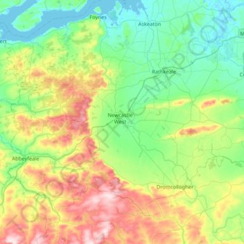
Name: The Municipal District of Newcastle West topographic map, elevation, terrain.
Average elevation: 117 m
Minimum elevation: -2 m
Maximum elevation: 407 m
Other topographic maps
Click on a map to view its topography, its elevation and its terrain.
Doon South
Ireland > County Limerick > The Municipal District of Cappamore — Kilmallock
Doon South, The Municipal District of Cappamore — Kilmallock, County Limerick, Munster, Ireland
Average elevation: 101 m
Market
Ireland > County Limerick > Limerick
Market, The Metropolitan District of Limerick City, Limerick, County Limerick, Munster, Ireland
Average elevation: 12 m
The Municipal District of Adare — Rathkeale
Ireland > County Limerick > The Municipal District of Adare — Rathkeale
The Municipal District of Adare — Rathkeale, County Limerick, Munster, Ireland
Average elevation: 74 m