Geolocate

County Mayo topographic map

Click on the map to display elevation.

About this map

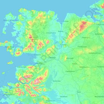
Name: County Mayo topographic map, elevation, terrain.

Location: County Mayo, Connacht, Ireland (53.47191 -10.32256 54.34542 -8.58283)

Average elevation: 66 m

Minimum elevation: -2 m

Maximum elevation: 766 m

Other topographic maps

Click on a map to view its topography, its elevation and its terrain.

Bunbrosna

Ireland > County Westmeath

Average elevation: 97 m

Ballinafad

Ireland > County Sligo

Average elevation: 115 m

Cleggan

Ireland > County Galway

Average elevation: 29 m

Dundrum

Ireland > County Dublin

Average elevation: 79 m

Saint Catherines

Ireland > County Clare

Average elevation: 91 m

Waterfall

Ireland > County Cork

Average elevation: 96 m

Great Blasket Island

Ireland > County Kerry

Average elevation: 21 m

Hollyfort

Ireland > County Wexford

Average elevation: 145 m

Lough Loung

Ireland > County Galway

Average elevation: 65 m

Aughrim

Ireland > County Galway

Average elevation: 68 m

Red Island

Ireland > County Cavan > Carrickclevan

Average elevation: 76 m

Mount Eagle

Ireland > County Mayo

Average elevation: 274 m

Broadford

Ireland > County Clare

Average elevation: 95 m

Comorant Rock

Ireland

Average elevation: 23 m

Limerick

Ireland > Limerick

Limerick's climate is classified as temperate oceanic (Köppen Cfb). Met Éireann maintains a climatological weather station at Shannon Airport, 20 kilometres west of the city in County Clare. Shannon Airport records an average of 977 millimetres of precipitation annually, most of which is rain. Limerick has a…

Average elevation: 10 m

Dún Laoghaire

Ireland > County Dublin

Average elevation: 21 m

Galway Bay

Ireland > County Galway

Average elevation: 35 m

Mullingar

Ireland > County Westmeath > Mullingar

Average elevation: 101 m

Westport

Ireland > County Mayo > Westport

Average elevation: 40 m

14

Ireland > County Dublin > Blackrock

Average elevation: 48 m

Caherdaniel

Ireland > County Kerry > Caherdaniel

Average elevation: 108 m

Listowel

Ireland > County Kerry > Listowel

Average elevation: 44 m

Tallaght

Ireland > County Dublin > Tallaght

Average elevation: 121 m

Priory

Ireland > County Kilkenny

Average elevation: 63 m

Sow

Ireland > County Wexford

Average elevation: 47 m

Gear up for your next adventure:

👟Sport Hiking Sandals - Breathable footwear for water crossings and camp rest
Lightweight Camping Tent - Portable shelter optimized for Canadian backcountry camping
🕯️Camping Lantern - Illuminates your entire campsite with high-efficiency LEDs
🧊Insulated Water Bottle - Keeps drinks cold in summer and prevents freezing in winter
Family Camping Tent - Spacious tent suitable for family camping trips

As an Amazon Associate, this site earns from qualifying purchases at no extra cost to you.