County Galway topographic map
Interactive map
Click on the map to display elevation.
About this map
![County Galway topographic map, elevation, terrain](/pub/maps/relation/6b18/39bcz/thumbnail.jpg)
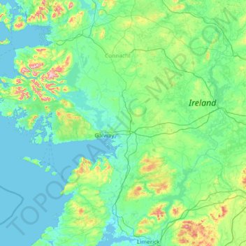
Name: County Galway topographic map, elevation, terrain.
Location: County Galway, Connacht, Ireland (52.96818 -10.31428 53.71886 -7.96782)
Average elevation: 68 m
Minimum elevation: -2 m
Maximum elevation: 772 m
Other topographic maps
Click on a map to view its topography, its elevation and its terrain.
![Doon South topographic map, elevation, terrain](/pub/maps/relation/fntp/9clq18/icon.jpg)
Doon South
Ireland > County Limerick > The Municipal District of Cappamore — Kilmallock
Doon South, The Municipal District of Cappamore — Kilmallock, County Limerick, Munster, Ireland
Average elevation: 101 m
![Irishtown topographic map, elevation, terrain](/pub/maps/relation/3frr/fb134s/icon.jpg)
Irishtown
Ireland > County Dublin > Dublin
Irishtown, Pembroke East A ED, Dublin, County Dublin, Leinster, Ireland
Average elevation: 5 m
![Ballinasloe Municipal District topographic map, elevation, terrain](/pub/maps/relation/ltnh/98gsgp/icon.jpg)
Ballinasloe Municipal District
Ballinasloe Municipal District, County Galway, Connacht, Ireland
Average elevation: 66 m
![Rathbane topographic map, elevation, terrain](/pub/maps/relation/8zm2/g1mqt6/icon.jpg)
Rathbane
Rathbane, Moynalty ED, The Municipal District of Kells, County Meath, Leinster, Ireland
Average elevation: 107 m
![Dundrum topographic map, elevation, terrain](/pub/maps/node/fc4s/1djlrrr/icon.jpg)
Dundrum
Dundrum, Dún Laoghaire-Rathdown, County Dublin, Leinster, D14 V9R3, Ireland
Average elevation: 79 m
![Cleggan topographic map, elevation, terrain](/pub/maps/node/c2tj/4w2svtp/icon.jpg)
Cleggan
Cleggan, Conamara Municipal District, County Galway, Connacht, H71 HY36, Ireland
Average elevation: 29 m
![Saint Catherines topographic map, elevation, terrain](/pub/maps/node/jrr/4w1r8tp/icon.jpg)
Saint Catherines
Saint Catherines, Boherglass ED, Killaloe Municipal District, County Clare, Munster, Ireland
Average elevation: 91 m
![Roundwood topographic map, elevation, terrain](/pub/maps/relation/dkgp/zjtz1h/icon.jpg)
Roundwood
Roundwood, The Municipal District of Wicklow, County Wicklow, Leinster, Ireland
Average elevation: 242 m
![Newfarm topographic map, elevation, terrain](/pub/maps/relation/g9zs/x2cz3l/icon.jpg)
Newfarm
Newfarm, The Rower, The Municipal District of Callan — Thomastown, County Kilkenny, Leinster, Ireland
Average elevation: 33 m
![Millstreet topographic map, elevation, terrain](/pub/maps/relation/2crr/cjw514/icon.jpg)
Millstreet
Millstreet, Municipal District of Macroom, County Cork, Munster, Ireland
Average elevation: 140 m
![Road topographic map, elevation, terrain](/pub/maps/relation/7j3l/93s1tf/icon.jpg)
Road
Road, Ballyburly ED, The Municipal District of Edenderry, County Offaly, Leinster, Ireland
Average elevation: 87 m
![Wexford topographic map, elevation, terrain](/pub/maps/relation/l1s8/d5j93l/icon.jpg)
Wexford
Wexford, The Borough District of Wexford, County Wexford, Leinster, Ireland
Average elevation: 23 m
![The Municipal District of Piltown topographic map, elevation, terrain](/pub/maps/relation/dbkl/rbb3t6/icon.jpg)
The Municipal District of Piltown
The Municipal District of Piltown, County Kilkenny, Leinster, Ireland
Average elevation: 89 m
![Dún Laoghaire-Rathdown topographic map, elevation, terrain](/pub/maps/relation/b357/szv2f3/icon.jpg)
Dún Laoghaire-Rathdown
Dún Laoghaire-Rathdown, County Dublin, Leinster, Ireland
Average elevation: 139 m
![Rathmichael (Bray) ED topographic map, elevation, terrain](/pub/maps/relation/zb57/xwntf3/icon.jpg)
Rathmichael (Bray) ED
Rathmichael (Bray) ED, The Municipal District of Bray, County Wicklow, Leinster, Ireland
Average elevation: 36 m
![Listowel topographic map, elevation, terrain](/pub/maps/relation/829m/jgkdmt/icon.jpg)
Listowel
Listowel, Listowel Municipal District, County Kerry, Munster, V31 YK58, Ireland
Average elevation: 43 m
![The Municipal District of Callan — Thomastown topographic map, elevation, terrain](/pub/maps/relation/351h/f43nm2/icon.jpg)
The Municipal District of Callan — Thomastown
The Municipal District of Callan — Thomastown, County Kilkenny, Leinster, Ireland
Average elevation: 100 m
![Elphin topographic map, elevation, terrain](/pub/maps/relation/17cz/j58rmt/icon.jpg)
Elphin
Elphin, Elphin ED, Boyle Municipal District, County Roscommon, Connacht, Ireland
Average elevation: 76 m
![Market topographic map, elevation, terrain](/pub/maps/relation/nrrr/tgr4tj/icon.jpg)
Market
Ireland > County Limerick > Limerick
Market, The Metropolitan District of Limerick City, Limerick, County Limerick, Munster, Ireland
Average elevation: 12 m
![Whitechurch topographic map, elevation, terrain](/pub/maps/relation/95tf/zszt5k/icon.jpg)
Whitechurch
Whitechurch, Municipal District of Cobh, County Cork, Munster, Ireland
Average elevation: 110 m
![Bailieborough topographic map, elevation, terrain](/pub/maps/relation/vd51/qb94gp/icon.jpg)
Bailieborough
Bailieborough, Bailieborough ED, Bailieborough-Cootehill Municipal District, County Cavan, Ulster, A82 NX86, Ireland
Average elevation: 162 m
![Waterfall topographic map, elevation, terrain](/pub/maps/node/sf18/l7xtd5nh/icon.jpg)
Waterfall
Waterfall, Inishkenny, Municipal District of Carrigaline, County Cork, Munster, T12 CYF2, Ireland
Average elevation: 96 m
![Cloyne topographic map, elevation, terrain](/pub/maps/relation/f5kl/qbkttp/icon.jpg)
Cloyne
Cloyne, Cloyne ED, The Municipal District of East Cork, County Cork, Munster, P25 P792, Ireland
Average elevation: 40 m
![Killeagh topographic map, elevation, terrain](/pub/maps/relation/whkl/wplf4s/icon.jpg)
Killeagh
Killeagh, The Municipal District of East Cork, County Cork, Munster, P36 KN61, Ireland
Average elevation: 64 m
![Aughrim topographic map, elevation, terrain](/pub/maps/relation/j157/v2f34s/icon.jpg)
Aughrim
Aughrim, The Municipal District of Arklow, County Wicklow, Leinster, Y14 HT72, Ireland
Average elevation: 123 m
![Gortnahoe topographic map, elevation, terrain](/pub/maps/relation/4hcz/6f5ltj/icon.jpg)
Gortnahoe
Gortnahoe, The Municipal District of Thurles, County Tipperary, Munster, Ireland
Average elevation: 135 m
![The Municipal District of Newcastle West topographic map, elevation, terrain](/pub/maps/relation/ssgt/dn49gp/icon.jpg)
The Municipal District of Newcastle West
The Municipal District of Newcastle West, County Limerick, Munster, Ireland
Average elevation: 117 m
![North West Slob topographic map, elevation, terrain](/pub/maps/relation/s814/5b65nx/icon.jpg)
North West Slob
North West Slob, Ardcavan ED, The Borough District of Wexford, County Wexford, Leinster, Ireland
Average elevation: 1 m
![Cliffs of Moher topographic map, elevation, terrain](/pub/maps/way/zn5k/jk2wktf/icon.jpg)
Cliffs of Moher
Cliffs of Moher, Ballysteen ED, West Clare Municipal District, County Clare, Munster, Ireland
Average elevation: 55 m
![Castledown topographic map, elevation, terrain](/pub/maps/relation/t1m2/78gf4s/icon.jpg)
Castledown
Castledown, Heathstown ED, The Municipal District of Mullingar — Kinnegad, County Westmeath, Leinster, Ireland
Average elevation: 97 m
![Hollyfort topographic map, elevation, terrain](/pub/maps/node/d9tf/dc4r4kl/icon.jpg)
Hollyfort
Hollyfort, The Municipal District of Gorey — Kilmuckridge, County Wexford, Leinster, Ireland
Average elevation: 145 m
![Lough Loung topographic map, elevation, terrain](/pub/maps/way/d7dn/qp35ctf/icon.jpg)
Lough Loung
Lough Loung, Ballynakill ED, Ballinasloe Municipal District, County Galway, Connacht, Ireland
Average elevation: 65 m
![Athlone topographic map, elevation, terrain](/pub/maps/relation/3w14/1c48b3/icon.jpg)
Athlone
Athlone, County Westmeath, Leinster, Ireland
Average elevation: 43 m
![Monbay Lower topographic map, elevation, terrain](/pub/maps/relation/fczs/fqc7b3/icon.jpg)
Monbay Lower
Monbay Lower, Rossminoge ED, The Municipal District of Gorey — Kilmuckridge, County Wexford, Leinster, Ireland
Average elevation: 136 m
![Ballymahon Municipal District topographic map, elevation, terrain](/pub/maps/relation/xm57/bftp18/icon.jpg)
Ballymahon Municipal District
Ballymahon Municipal District, County Longford, Leinster, Ireland
Average elevation: 63 m
![Mountain River topographic map, elevation, terrain](/pub/maps/relation/kd3l/6h4ptj/icon.jpg)
Mountain River
Mountain River, The Municipal District of Muinebeag, County Carlow, Leinster, Ireland
Average elevation: 136 m
![The Municipal District of Gorey — Kilmuckridge topographic map, elevation, terrain](/pub/maps/relation/fkgp/qxdfkl/icon.jpg)
The Municipal District of Gorey — Kilmuckridge
The Municipal District of Gorey — Kilmuckridge, County Wexford, Leinster, Ireland
Average elevation: 58 m
![Kilquane topographic map, elevation, terrain](/pub/maps/relation/dk3l/fnshtp/icon.jpg)
Kilquane
Ireland > County Cork > Municipal District of Cobh
Kilquane, Knockraha, Municipal District of Cobh, County Cork, Munster, Ireland
Average elevation: 131 m
![Red Island topographic map, elevation, terrain](/pub/maps/way/8wz4/dmrmmnh/icon.jpg)
Red Island
Ireland > County Cavan > Carrickclevan
Red Island, Carrickclevan, Drumcarban ED, Ballyjamesduff Municipal District, County Cavan, Ulster, Ireland
Average elevation: 76 m