Geolocate

Calary topographic map

Interactive map

Click on the map to display elevation.

About this map

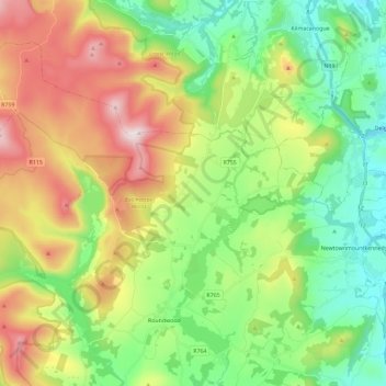
Name: Calary topographic map, elevation, terrain.

Location: Calary, County Wicklow, Leinster, Ireland (53.05479 -6.34477 53.16345 -6.11379)

Average elevation: 295 m

Minimum elevation: 48 m

Maximum elevation: 719 m

Other topographic maps

Click on a map to view its topography, its elevation and its terrain.

Roundwood

Ireland > County Wicklow

Roundwood, The Municipal District of Wicklow, County Wicklow, Leinster, Ireland

Average elevation: 242 m

Rathmichael (Bray) ED

Ireland > County Wicklow

Rathmichael (Bray) ED, The Municipal District of Bray, County Wicklow, Leinster, Ireland

Average elevation: 36 m

Aughrim

Ireland > County Wicklow

Aughrim, The Municipal District of Arklow, County Wicklow, Leinster, Y14 HT72, Ireland

Average elevation: 123 m

Toberbeg

Ireland > County Wicklow

Toberbeg, Dunlavin ED, The Municipal District of Baltinglass, County Wicklow, Leinster, Ireland

Average elevation: 207 m