
West Tennessee topographic map
Click on the map to display elevation.
West Tennessee
West Tennessee is located almost entirely within the Mississippi Embayment, part of the Gulf Coastal Plain. Because of this, the terrain is flatter than the eastern parts of the state. Areas along the Mississippi River are located within the Mississippi Alluvial Plain, which is primarily a floodplain with many swamps. However, much of the western counties of the region are protected from flooding by the Chickasaw Bluffs, ridges of loess rising 50 to 200 feet (15 to 61 m) above the floodplain. Although the land is lower and flatter than Middle and East Tennessee, some hilly terrain exists, especially along the bluffs bordering the Mississippi River and the land bordering the Tennessee River, known as the West Tennessee Highlands. Hilly land in these areas is forested. Otherwise, most of the land in West Tennessee is used as farmland. The soil in this part of the state comes from when a prehistoric sea dried up and left sediment in its place. Unlike in the rest of the state, bedrock is buried a few thousand feet below the surface. West Tennessee's highest elevation is approximately 840 feet (260 m) in Hardin County east of the Tennessee River, which is slightly lower than the state's mean elevation of 900 feet (270 m); the region's highest elevation west of the Tennessee River is approximately 740 feet (230 m) in Chester County.
About this map
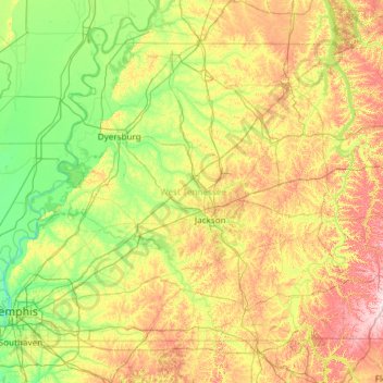
Name: West Tennessee topographic map, elevation, terrain.
Location: West Tennessee, Tennessee, United States (34.99372 -90.31030 36.50723 -87.91657)
Average elevation: 127 m
Minimum elevation: 56 m
Maximum elevation: 325 m
Other topographic maps
Click on a map to view its topography, its elevation and its terrain.
Cordova
United States > Tennessee > Shelby County > Memphis
Cordova is a community in Shelby County, Tennessee, United States. Cordova lies east of Memphis, north of Germantown, south of Bartlett, and northwest of Collierville at an elevation of 361 feet (110 meters).
Average elevation: 99 m
East Lake
United States > Tennessee > Hamilton County > Chattanooga > East Ridge
Average elevation: 231 m
Whites Village
United States > Tennessee > Knox County > Knoxville > Whites Village
Average elevation: 288 m
Antioch
United States > Tennessee > Davidson County > Nashville-Davidson > Antioch
Average elevation: 175 m
College Grove
United States > Tennessee > Roane County > Rockwood > College Grove
Average elevation: 277 m