Geolocate

Clarksville topographic map

Click on the map to display elevation.

About this map

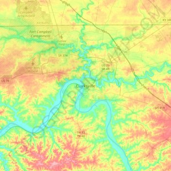
Name: Clarksville topographic map, elevation, terrain.

Location: Clarksville, Montgomery County, Tennessee, 37044, United States (36.36776 -87.51887 36.68776 -87.19887)

Average elevation: 161 m

Minimum elevation: 108 m

Maximum elevation: 234 m

Other topographic maps

Click on a map to view its topography, its elevation and its terrain.

Gear up for your next adventure:

🚲Handlebar Phone Mount - View topographic-map.com live while cycling
🛌Insulated Sleeping Pad - Critical thermal barrier between you and the cold ground
🧥Waterproof Hiking Jacket - Protect yourself from rain and wind while hiking
🥾Light Hiking Boots - Lightweight and comfortable boots for day hikes
🚲Bike Repair Kit - Essential tools for on-trail mechanical issues

As an Amazon Associate, this site earns from qualifying purchases at no extra cost to you.