Geolocate

Sevierville topographic map

Click on the map to display elevation.

About this map

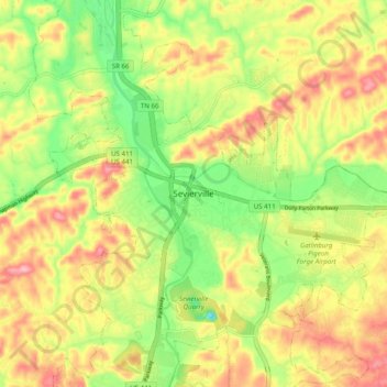
Name: Sevierville topographic map, elevation, terrain.

Location: Sevierville, Sevier County, Tennessee, United States (35.82671 -83.60205 35.90671 -83.52205)

Average elevation: 305 m

Minimum elevation: 234 m

Maximum elevation: 374 m

Other topographic maps

Click on a map to view its topography, its elevation and its terrain.

Sevierville

United States > Tennessee > Sevier County

Average elevation: 313 m

Gear up for your next adventure:

🛶Canoe Life Vest - Safety vest for water sports
🚲Bike Repair Kit - Essential tools for on-trail mechanical issues
🎒Hiking Backpack - Lightweight and ergonomic backpacks for day hikes or multi-day treks
🧢Outdoor Cap - Protective cap for sun and rain during hikes
🥾Mountain Trail Shoes - High-traction shoes for mountain trails

As an Amazon Associate, this site earns from qualifying purchases at no extra cost to you.