
Arusha topographic map
Click on the map to display elevation.
Arusha
The Great Rift Valley runs through the middle of the region north-to-south. Oldonyo Lengai (Mountain of God in the Maasai language) is an active volcano to the north of the Ngorongoro Conservation Area. Altitudes throughout the region vary widely, but much of it ranges from 900 to 1,600 metres (3,000 to 5,200 ft) in elevation.
About this map
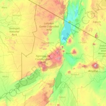
Name: Arusha topographic map, elevation, terrain.
Location: Arusha, Northern Zone, Tanzania (-4.15051 34.75004 -1.68655 37.42877)
Average elevation: 1,440 m
Minimum elevation: 594 m
Maximum elevation: 4,271 m
Other topographic maps
Click on a map to view its topography, its elevation and its terrain.
Uhuru Peak
Kilimanjaro is the fourth most topographically prominent peak on Earth. It is part of Kilimanjaro National Park and is a major hiking and climbing destination. Because of its shrinking glaciers and ice fields, which are projected to disappear between 2025 and 2035, it has been the subject of many scientific…
Average elevation: 5,494 m
Mwanza
Mwanza features a tropical savanna climate under the Köppen climate classification. Temperatures are relatively consistent throughout the course of the year, tempered by the city's altitude. Thus, the climate is not quite as hot as one might expect, given the city's location near the equator. Average…
Average elevation: 1,178 m
Arusha
Despite its proximity to the equator, Arusha's elevation of 1,400 metres (4,600 ft) on the southern slopes of Mount Meru keeps temperatures relatively low and alleviates humidity. Cool dry air is prevalent for much of the year. The temperature typically ranges between 10 and 30 °C (50 and 86 °F) with an…
Average elevation: 1,572 m
Dodoma
Tanzania > Dodoma Region > Dodoma
The official capital since 1996, Dodoma was envisaged as the first non-monumental capital city as opposed to the monumentality and hierarchy of other planned capital cities such as Abuja, Brasília and Washington, D.C. It rejected geometrical forms such as grid iron and radial plans as inappropriate as the…
Average elevation: 1,145 m