
Klazienaveen topographic map
Interactive map
Click on the map to display elevation.
About this map
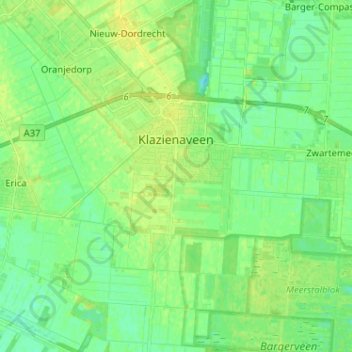
Name: Klazienaveen topographic map, elevation, terrain.
Location: Klazienaveen, Emmen, Drenthe, Nederland (52.67854 6.95357 52.75621 7.03704)
Average elevation: 19 m
Minimum elevation: 11 m
Maximum elevation: 27 m
Other topographic maps
Click on a map to view its topography, its elevation and its terrain.
Oud Annerveen
Oud Annerveen, Aa en Hunze, Drenthe, Nederland
Average elevation: 2 m
Oosterbroek
Oosterbroek, Eelde, Tynaarlo, Drenthe, Nederland, 9761 TG, Nederland
Average elevation: 3 m
Oosterhesselen
Nederland > Drenthe > Coevorden
Oosterhesselen, Coevorden, Drenthe, Nederland
Average elevation: 15 m
Nieuw-Buinen
Nederland > Drenthe > Nieuw-Buinen
Nieuw-Buinen, Borger-Odoorn, Drenthe, Nederland
Average elevation: 7 m