
Brome-Missisquoi topographic map
Interactive map
Click on the map to display elevation.
About this map
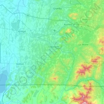
Name: Brome-Missisquoi topographic map, elevation, terrain.
Location: Brome-Missisquoi, Quebec, Canada (45.00777 -73.13984 45.35205 -72.40005)
Average elevation: 182 m
Minimum elevation: 28 m
Maximum elevation: 1,157 m
Quebec trails, hiking, mountain biking, running and outdoor activities
Other topographic maps
Click on a map to view its topography, its elevation and its terrain.
Valcartier
Canada > Quebec > La Jacques-Cartier > Saint-Gabriel-de-Valcartier
Average elevation: 170 m
Mount Royal
Canada > Quebec > Urban agglomeration of Montreal > Montreal
The hill is part of the Monteregian Hills situated between the Laurentians and the Appalachian Mountains. It gave its Latin name, Mons Regius, to the Monteregian chain. The hill consists of three peaks: Colline de la Croix (or Mont Royal proper) at 233 m (764 ft), Colline d'Outremont (or Mount Murray, in the…
Average elevation: 111 m
Saint Helen's Island
Canada > Quebec > Urban agglomeration of Montreal > Montreal
Average elevation: 15 m
Tête-à-la-Baleine
Canada > Quebec > Le Golfe-du-Saint-Laurent > Côte-Nord-du-Golfe-du-Saint-Laurent
Average elevation: 24 m
Magdalen Islands
Canada > Quebec > Urban agglomeration of Les Îles-de-la-Madeleine
Average elevation: 1 m
Baie-Rouge
Canada > Quebec > Le Golfe-du-Saint-Laurent > Gros-Mécatina > La Tabatière
Average elevation: 12 m
Mont Raoul-Blanchard
Canada > Quebec > La Côte-de-Beaupré > Lac-Jacques-Cartier
Average elevation: 982 m
Mont Victor-Tremblay
Canada > Quebec > Le Fjord-du-Saguenay > Saint-David-de-Falardeau
Average elevation: 626 m
Parc Léon-Provancher
Canada > Quebec > Urban agglomeration of Montreal > Montreal
Average elevation: 53 m
Saint-Michel-de-Wentworth
Canada > Quebec > Les Pays-d'en-Haut > Wentworth-Nord
Average elevation: 320 m
Havre-aux-Maisons
Canada > Quebec > Urban agglomeration of Les Îles-de-la-Madeleine > Les Îles-de-la-Madeleine
Average elevation: 15 m
Colline de l'Abri
Canada > Quebec > Urban agglomeration of Montreal > Montreal
Average elevation: 120 m
Gault Nature Reserve
Canada > Quebec > La Vallée-du-Richelieu > Mont-Saint-Hilaire
Average elevation: 189 m
Rivière-la-Madeleine
Canada > Quebec > La Haute-Gaspésie > Sainte-Madeleine-de-la-Rivière-Madeleine
Average elevation: 46 m
Lac du Bois Franc
Canada > Quebec > Témiscamingue > Les Lacs-du-Témiscamingue
Average elevation: 398 m
Scouts Canada - Lake Lovering Scouts Reserve
Canada > Quebec > Memphrémagog > Magog
Average elevation: 260 m
Madeleine-Centre
Canada > Quebec > La Haute-Gaspésie > Sainte-Madeleine-de-la-Rivière-Madeleine
Average elevation: 72 m
Saint-Louis-de-Masham
Canada > Quebec > Les Collines-de-l'Outaouais > La Pêche
Average elevation: 186 m
Lac de la Montagne Brûlée
Canada > Quebec > Urban agglomeration of La Tuque > Lac-Édouard
Average elevation: 437 m
Saint-Marc-du-Lac-Long
Canada > Quebec > Témiscouata > Saint-Marc-du-Lac-Long
Average elevation: 258 m