
Grad topographic map
Interactive map
Click on the map to display elevation.
About this map
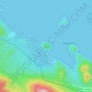
Name: Grad topographic map, elevation, terrain.
Location: Grad, Općina Janjina, Dubrovnik-Neretva County, 20247, Croatia (42.91906 17.46770 42.91916 17.46780)
Average elevation: 28 m
Minimum elevation: -2 m
Maximum elevation: 218 m
Other topographic maps
Click on a map to view its topography, its elevation and its terrain.
Grad Požega
Croatia > Požega-Slavonia County
Požega (elevation: 152 m (499 ft)) is located in the south-western part of the Valley of Požega, or Požega basin, in Croatian: Požeška kotlina. This fertile valley has been important since the antiquity - its Roman name was Vallis Aurea, meaning "golden valley".
Average elevation: 222 m
Plitvice Lakes National Park
Croatia > Lika-Senj County > Plitvički Ljeskovac
The afforested mountain slopes serve as water reservoirs. They are also a refuge for many animal species. The large difference in altitude in a narrow space between the mountains in the south and the Korana river in the north also represents a significant criterion for biodiversity in this region. The overall…
Average elevation: 765 m