Geolocate

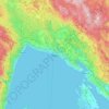
Istra topographic map

Click on the map to display elevation.

About this map
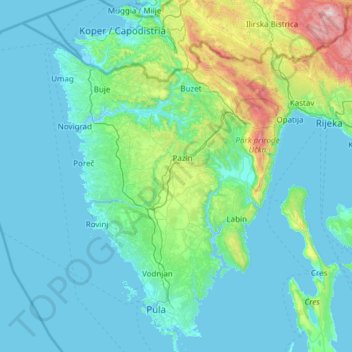
Name: Istra topographic map, elevation, terrain.

Location: Istra, Croatia (44.76605 13.48990 45.62081 14.32908)

Average elevation: 183 m

Minimum elevation: -5 m

Maximum elevation: 1,747 m

Other topographic maps

Click on a map to view its topography, its elevation and its terrain.
Split

Croatia > Split

Average elevation: 205 m

Rijeka

Croatia > Primorje-Gorski Kotar County

Average elevation: 386 m

Bitorajci

Croatia > Karlovac County

Average elevation: 213 m

Breze

Croatia > Primorje-Gorski Kotar County

Average elevation: 872 m

Ozalj

Croatia > Karlovac County

Average elevation: 179 m

Nova Vas

Croatia > Istria County > Grad Poreč

Average elevation: 112 m

Brezovac

Croatia > Karlovac County

Average elevation: 341 m

Svetičko Hrašće

Croatia > Karlovac County

Average elevation: 278 m

Gaćelezi

Croatia > Šibenik-Knin County > Grad Vodice

Average elevation: 91 m

Ribarići

Croatia > Karlovac County > Grad Ogulin

Average elevation: 400 m

Omiš

Croatia > Zadar County > Općina Preko

Average elevation: 8 m

Gear up for your next adventure:

🎒Hiking Daypack - Lightweight and durable backpacks for day trips and excursions
👟Sport Hiking Sandals - Breathable footwear for water crossings and camp rest
🧣Evaporative Cooling Towel - Beat the heat during intense summer climbs
🧴Sunscreen SPF - Broad-spectrum sunscreen for outdoor activities
🩹Compact First Aid Kit - Pre-packed essentials for common trail injuries

As an Amazon Associate, this site earns from qualifying purchases at no extra cost to you.