Geolocate

Nin topographic map

Click on the map to display elevation.

About this map

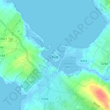
Name: Nin topographic map, elevation, terrain.

Location: Nin, Grad Nin, Zadar County, 23223, Croatia (44.22834 15.14644 44.25953 15.20951)

Average elevation: 6 m

Minimum elevation: -5 m

Maximum elevation: 30 m

Gear up for your next adventure:

🍽️Titanium Camping Spork - Ultralight and indestructible eating utensil
💡Portable Camping Lamp - Rechargeable lamp for campsite lighting
🪑Ultralight Camping Stool - Compact seating for rest stops during long hikes
🚲Handlebar Phone Mount - View topographic-map.com live while cycling
Camping Essentials - All-in-one gear for a comfortable camping trip

As an Amazon Associate, this site earns from qualifying purchases at no extra cost to you.