Geolocate

Grad Rijeka topographic map

Click on the map to display elevation.

About this map

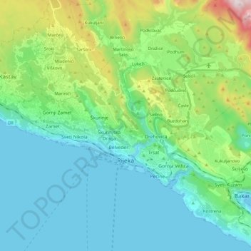
Name: Grad Rijeka topographic map, elevation, terrain.

Location: Grad Rijeka, Primorje-Gorski Kotar County, Croatia (45.30744 14.33193 45.38405 14.53097)

Average elevation: 209 m

Minimum elevation: -1 m

Maximum elevation: 977 m

Other topographic maps

Click on a map to view its topography, its elevation and its terrain.

Dolovo

Croatia > Primorje-Gorski Kotar County > Dolovo

Average elevation: 235 m

Dolovo

Croatia > Primorje-Gorski Kotar County > Dolovo

Average elevation: 235 m

Liplje

Croatia > Primorje-Gorski Kotar County

Average elevation: 235 m

Brešca

Croatia > Primorje-Gorski Kotar County

Average elevation: 375 m

Selo

Croatia > Primorje-Gorski Kotar County

Average elevation: 868 m

Belo

Croatia > Primorje-Gorski Kotar County

Average elevation: 350 m

Turke

Croatia > Primorje-Gorski Kotar County

Average elevation: 507 m

Tribalj

Croatia > Primorje-Gorski Kotar County

Average elevation: 226 m

Radovanj

Croatia > Primorje-Gorski Kotar County

Average elevation: 491 m

Sunger

Croatia > Primorje-Gorski Kotar County

Average elevation: 887 m

Gomirje

Croatia > Primorje-Gorski Kotar County

Average elevation: 431 m

Rijeka

Croatia > Primorje-Gorski Kotar County

Average elevation: 384 m

Seka

Croatia > Primorje-Gorski Kotar County

Average elevation: 14 m

Šmrika

Croatia > Primorje-Gorski Kotar County

Average elevation: 165 m

Rudine

Croatia > Primorje-Gorski Kotar County

Average elevation: 18 m

Punat

Croatia > Primorje-Gorski Kotar County

Average elevation: 94 m

Gear up for your next adventure:

🧦Thermal Socks - Warm socks for winter hiking or camping
🧥Thermal Layer - Insulating layer for cold outdoor conditions
Tent Footprint - Protect tent floor and increase durability
💧Filtered Water Bottle - Safe drinking water on the go
🧭GPS Handheld Device - Reliable GPS navigation for outdoor adventures

As an Amazon Associate, this site earns from qualifying purchases at no extra cost to you.