Geolocate

Grad Pula topographic map

Click on the map to display elevation.

About this map

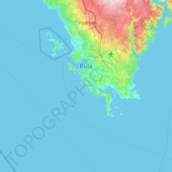
Name: Grad Pula topographic map, elevation, terrain.

Location: Grad Pula, Istria County, Croatia (44.68729 13.42022 44.97139 13.91682)

Average elevation: 23 m

Minimum elevation: -2 m

Maximum elevation: 255 m

Other topographic maps

Click on a map to view its topography, its elevation and its terrain.

Nova Vas

Croatia > Istria County > Grad Poreč

Average elevation: 112 m

Gear up for your next adventure:

🧢Hiking Sun Hat - Wide-brimmed protection for exposed mountain ridges
🔦LED Headtorch - Bright and durable light for night activities
🥾Mountain Hiking Shoes - Shoes with superior grip for mountainous terrain
🥾Waterproof Hiking Boots - Boots keeping your feet dry in wet conditions
🧥Thermal Fleece Jacket - Versatile insulation for changing mountain temperatures

As an Amazon Associate, this site earns from qualifying purchases at no extra cost to you.